1
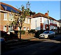
Cranmer Court, Llandaff, Cardiff
Flats built c1975 set back from the northwest side of Ely Road.
Image: © Jaggery
Taken: 12 Sep 2017
0.02 miles
2
Caewal Road, Llandaff, Cardiff
From Western Avenue north along Caewal Road towards Ely Road.
Image: © Jaggery
Taken: 12 Sep 2017
0.03 miles
3
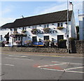
East side of the Maltsters, Llandaff, Cardiff
The Ely Road side of this http://www.geograph.org.uk/photo/5534403 Cardiff Road pub.
Image: © Jaggery
Taken: 12 Sep 2017
0.06 miles
4
Rooftop solar panels, Caewal Road, Llandaff, Cardiff
On an east facing roof.
Image: © Jaggery
Taken: 12 Sep 2017
0.07 miles
5
Maltsters, Llandaff, Cardiff
The Cardiff Road side of the pub on the corner of Ely Road, viewed from
the corner of High Street. The Maltsters was formerly the Maltsters Arms.
Image: © Jaggery
Taken: 12 Sep 2017
0.08 miles
6
From Cardiff Road Llandaff towards the 1st Llandaff Scout Group, Cardiff
The side road leads to the scout hall. 1st Llandaff Scout Group is part of
the Cardiff West District within Cardiff and the Vale of Glamorgan Scout Area.
Image: © Jaggery
Taken: 12 Sep 2017
0.08 miles
7
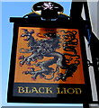
Black Lion name sign, Llandaff, Cardiff
On a wall bracket on the left here. http://www.geograph.org.uk/photo/5534393
Image: © Jaggery
Taken: 12 Sep 2017
0.08 miles
8
Ordnance Survey Cut Mark
This OS cut mark can be found on the Court of Probate building, Cardiff Road. It marks a point 24.520m above mean sea level.
Image: © Adrian Dust
Taken: 11 Nov 2017
0.09 miles
9
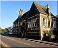
Grade II (star) listed number 49 Cardiff Road, Llandaff, Cardiff
Cadw records that this building was erected in 1860-1863 as the National Probate Registry for Wales, designed by John Prichard, the pre-eminent Victorian architect of South Wales. This is possibly his finest secular design.
A commercial type building of such elaborate design outside a city centre is unusual for this date and reflects the importance of its function. Probate had been an ecclesiastical function until 1857. The building was converted for modern office use c1990. Though much changed internally, it is little changed externally from its original appearance.
Image: © Jaggery
Taken: 12 Sep 2017
0.09 miles
10
South side of the Black Lion pub, Llandaff, Cardiff
The Cardiff Road side of the pub on the corner of High Street. The Llandaff City website states that the pub is so named because a black lion appears as part of the heraldic shield of the Mathew family of Llandaff. Three of their family tombs are in Llandaff Cathedral and other members have wall memorials there.
For part of the 19th century the pub was known as The Romilly, after Sir Samuel Romilly MP, the Solicitor General and a leading antislavery campaigner, acquired the Manor of Llandaff from the Mathew family in 1817. His family sold the Manor to W S Cartwright in 1852 whereupon the pub name reverted to the Black Lion.
http://www.geograph.org.uk/photo/5534398 to the name sign on the left.
Image: © Jaggery
Taken: 12 Sep 2017
0.09 miles


