IMAGES TAKEN NEAR TO
Clos Y Gadwyn, CF5 2FB
Introduction
This page details the photographs taken nearby to Clos Y Gadwyn, CF5 2FB by members of the Geograph project.
The Geograph project started in 2005 with the aim of publishing, organising and preserving representative images for every square kilometre of Great Britain, Ireland and the Isle of Man.

There are currently over 7.5m images from over14,400 individuals and you can help contribute to the project by visiting https://www.geograph.org.uk
Image Map
Images are licensed for reuse under creativecommons.org/licenses/by-sa/2.0
Notes
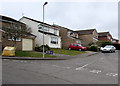
- Clicking on the map will re-center to the selected point.
- The higher the marker number, the further away the image location is from the centre of the postcode.
Image Listing (52 Images Found)
Images are licensed for reuse under creativecommons.org/licenses/by-sa/2.0
Image
Details
Distance
1
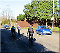
Friday cyclists on Llantrisant Road, Radyr, Cardiff
Travelling north on the A4119 Llantrisant Road on a sunny Friday in late January 2018.
Image: © Jaggery
Taken: 26 Jan 2018
0.04 miles
2
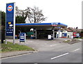
Radyr Filling Station, Cardiff
Gulf fuel station and small shop, viewed across Llantrisant Road.
Image: © Jaggery
Taken: 5 Mar 2015
0.05 miles
3
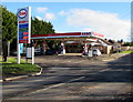
Radyr Filling Station, Llantrisant Road, Cardiff
An Esso filling station and Spar shop viewed across the A4119 Llantrisant Road in January 2018.
A Gulf filling station https://www.geograph.org.uk/photo/4373867 was here in March 2015.
Image: © Jaggery
Taken: 26 Jan 2018
0.06 miles
4
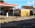
Spar shop in Radyr Filling Station, Llantrisant Road, Cardiff
Behind the Esso filling station here. https://www.geograph.org.uk/photo/5662435
Image: © Jaggery
Taken: 26 Jan 2018
0.06 miles
5
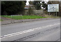
Danescourt and Pentrebane junctions ahead, Radyr, Cardiff
The sign is alongside Llantrisant Road, near a path https://www.geograph.org.uk/photo/5662459 to Heol Aradur.
Image: © Jaggery
Taken: 5 Mar 2015
0.06 miles
6
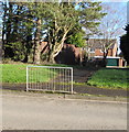
Path to Heol Aradur, Cardiff
From the A4119 Llantrisant Road to houses in the road named Heol Aradur.
Image: © Jaggery
Taken: 26 Jan 2018
0.07 miles
7
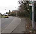
Radyr Chain bus stop, Cardiff
Alongside Llantrisant Road. Radyr Chain is a Grade II listed late Victoria villa http://www.geograph.org.uk/photo/4373884 c200 metres ahead.
The vehicle with red and yellow chevrons is an ambulance.
Image: © Jaggery
Taken: 5 Mar 2015
0.09 miles
8
Heol Aradur, Cardiff
Viewed from the Danescourt Way end of Heol Aradur. There is not meant to be a route for vehicles across the grass to or from Danescourt Way, but tyre marks on the grass http://www.geograph.org.uk/photo/4374057 are evidence of at least one recent vehicle passing this way.
Image: © Jaggery
Taken: 5 Mar 2015
0.11 miles
9
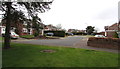
Vista Rise, Cardiff
Cul-de-sac on the north side of Restways Close.
Image: © Jaggery
Taken: 5 Mar 2015
0.13 miles
10
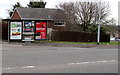
Bus shelter adverts in Radyr, Cardiff
A Clear Channel advertising site alongside Llantrisant Road. Clear Channel's website states
"We find innovative ways for brands to meet and engage people while they're out and about".
Image: © Jaggery
Taken: 5 Mar 2015
0.14 miles