1
Ordnance Survey Cut Mark
This OS cut mark can be found on No66 Cardiff Road. It marks a point 21.342m above mean sea level.
Image: © Adrian Dust
Taken: 11 Nov 2017
0.04 miles
2
St Michael's College, Llandaff
St Michael's is a theological college serving the Anglican and Methodist Churches and the work of chaplaincy in partnership with Cardiff University.
Image: © Robin Drayton
Taken: 8 Mar 2011
0.05 miles
3
Milepost, Cardiff Road, Llandaff
The milepost is sited on Cardiff Road, near the main entrance to The Cathedral School. The post indicates that it is 2 miles to Cardiff, over 8 miles to Llantrisant and a quarter of a mile into Llandaff.
Image: © Martyn Harries
Taken: 19 Sep 2009
0.06 miles
4
Mile Stone - Cardiff 2
NE side of the road.
Image: © Adrian Dust
Taken: 11 Nov 2017
0.06 miles
5
Cardiff Road, Llandaff
Looking downhill towards Cardiff at a time when this main road is uncharacteristically quiet.
Image: © Colin Smith
Taken: 21 Sep 2008
0.07 miles
6
Old Milepost by the A4119, Cardiff Road, Llandaff
Milepost by the A4119, in parish of Llandaff (City of Cardiff District), Llandaff, Cardiff Road, outside the Cathedral School, North side of road.
Inscription reads:-
: CARDIFF / 2 / MILES : : LANDAFF / ¼ : : LANTRIS- / SANT / 8¼ / MILES :
Grade II listed by Cadw.
Reference Number 81274: https://cadwpublic-api.azurewebsites.net/reports/listedbuilding/FullReport?lang=&id=81274
Surveyed
Milestone Society National ID: GLA_CFLT02
Image: © Milestone Society
Taken: Unknown
0.07 miles
7
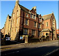
North side of St Michael's College, Llandaff, Cardiff
Viewed across the A4119 Cardiff Road. St Michael's College is an Anglican theological college located near Llandaff Cathedral. The college buildings are Grade II listed.
Image: © Jaggery
Taken: 12 Sep 2017
0.08 miles
8
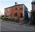
Southern end of Chapel Street, Llandaff, Cardiff
From the north side of the A4119 Cardiff Road, narrow Chapel Street leads to the east side of High Street.
Image: © Jaggery
Taken: 12 Sep 2017
0.08 miles
9
Ordnance Survey Cut Mark
This OS cut mark can be found on No98 Cardiff Road. It marks a point 20.102m above mean sea level.
Image: © Adrian Dust
Taken: 11 Nov 2017
0.08 miles
10
North along Chapel Street, Llandaff, Cardiff
From the A4119 Cardiff Road, narrow Chapel Street leads to High Street.
Image: © Jaggery
Taken: 12 Sep 2017
0.09 miles


