IMAGES TAKEN NEAR TO
The Crescent, CARDIFF, CF5 2DL
Introduction
This page details the photographs taken nearby to The Crescent, CF5 2DL by members of the Geograph project.
The Geograph project started in 2005 with the aim of publishing, organising and preserving representative images for every square kilometre of Great Britain, Ireland and the Isle of Man.

There are currently over 7.5m images from over14,400 individuals and you can help contribute to the project by visiting https://www.geograph.org.uk
Image Map
Images are licensed for reuse under creativecommons.org/licenses/by-sa/2.0
Notes
- Clicking on the map will re-center to the selected point.
- The higher the marker number, the further away the image location is from the centre of the postcode.
Image Listing (136 Images Found)
Images are licensed for reuse under creativecommons.org/licenses/by-sa/2.0
Image
Details
Distance
1
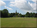
Cricket near Llandaff
A match is played in the shadow of Llandaff Cathedral.
Image: © Gareth James
Taken: 20 Jun 2010
0.05 miles
2
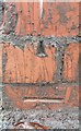
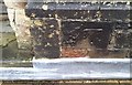
Ordnance Survey Cut Mark
This OS damaged and moved cut mark can be found on the wall post of No130 Cardiff Road. It marks a point 19.507m above mean sea level.
Image: © Adrian Dust
Taken: 11 Nov 2017
0.07 miles
3
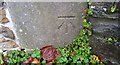
Ordnance Survey Cut Mark
This OS cut mark can be found on No98 Cardiff Road. It marks a point 20.102m above mean sea level.
Image: © Adrian Dust
Taken: 11 Nov 2017
0.09 miles
4
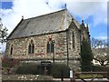
School Chapel
Chapel of the Cathedral School, Llandaff.
Image: © Alan Hughes
Taken: 7 Apr 2016
0.09 miles
5
Ordnance Survey Cut Mark
This OS cut mark can be found on the NW face of the Cathedral School Chapel. It marks a point 24.771m above mean sea level.
Image: © Adrian Dust
Taken: 11 Nov 2017
0.09 miles
6
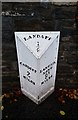
Mile Stone - Cardiff 2
NE side of the road.
Image: © Adrian Dust
Taken: 11 Nov 2017
0.11 miles
7
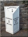
Old Milepost by the A4119, Cardiff Road, Llandaff
Milepost by the A4119, in parish of Llandaff (City of Cardiff District), Llandaff, Cardiff Road, outside the Cathedral School, North side of road.
Inscription reads:-
: CARDIFF / 2 / MILES : : LANDAFF / ¼ : : LANTRIS- / SANT / 8¼ / MILES :
Grade II listed by Cadw.
Reference Number 81274: https://cadwpublic-api.azurewebsites.net/reports/listedbuilding/FullReport?lang=&id=81274
Surveyed
Milestone Society National ID: GLA_CFLT02
Image: © Milestone Society
Taken: Unknown
0.11 miles
10
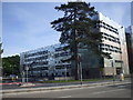
The new WJEC building, Western Ave, Cardiff
Image: © John Lord
Taken: 31 May 2010
0.13 miles