IMAGES TAKEN NEAR TO
Deans Close, CARDIFF, CF5 2BR
Introduction
This page details the photographs taken nearby to Deans Close, CF5 2BR by members of the Geograph project.
The Geograph project started in 2005 with the aim of publishing, organising and preserving representative images for every square kilometre of Great Britain, Ireland and the Isle of Man.

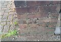
There are currently over 7.5m images from over14,400 individuals and you can help contribute to the project by visiting https://www.geograph.org.uk
Image Map
Images are licensed for reuse under creativecommons.org/licenses/by-sa/2.0
Notes
- Clicking on the map will re-center to the selected point.
- The higher the marker number, the further away the image location is from the centre of the postcode.
Image Listing (84 Images Found)
Images are licensed for reuse under creativecommons.org/licenses/by-sa/2.0
Image
Details
Distance
1
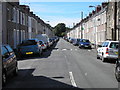
Ethel street, Canton, Cardiff
Ethel street I'm told is the longest street in Cardiff with no turnings off it. It's also where I bought my first house.
Image: © Steve Chapple
Taken: 21 Aug 2005
0.06 miles
2
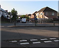
A48 through Caewal Road, Cardiff
The east-west course of the A48 Western Avenue bisects the north-south course of Caewal Road. On the camera side, traffic from Caewal Road towards the A48 must turn left here. The southern part of Caewal Road is ahead.
Image: © Jaggery
Taken: 12 Sep 2017
0.10 miles
3
Rooftop solar panels, Caewal Road, Llandaff, Cardiff
On an east facing roof.
Image: © Jaggery
Taken: 12 Sep 2017
0.12 miles
4
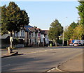
West along Western Avenue, Cardiff
The A48 Western Avenue viewed from the corner of Caewal Road.
Image: © Jaggery
Taken: 12 Sep 2017
0.13 miles
5
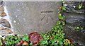
Ordnance Survey Cut Mark
This OS cut mark can be found on No98 Cardiff Road. It marks a point 20.102m above mean sea level.
Image: © Adrian Dust
Taken: 11 Nov 2017
0.13 miles
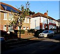
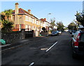
6
Palace Road, Cardiff
The SE end of Palace Road, viewed from the corner of Pencisely Road.
Image: © Jaggery
Taken: 22 Jul 2010
0.14 miles
7
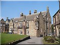
St Michael's College, Llandaff
St Michael's is a theological college serving the Anglican and Methodist Churches and the work of chaplaincy in partnership with Cardiff University.
Image: © Robin Drayton
Taken: 8 Mar 2011
0.14 miles
8
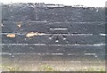
Ordnance Survey Cut Mark
This OS cut mark can be found on No66 Cardiff Road. It marks a point 21.342m above mean sea level.
Image: © Adrian Dust
Taken: 11 Nov 2017
0.14 miles
9
Ordnance Survey Cut Mark
This OS cut mark can be found on the gatepost of No137 Pencisely Road. It marks a point 15.164m above mean sea level.
Image: © Adrian Dust
Taken: 23 Sep 2021
0.14 miles
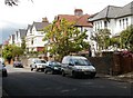
10
Caewal Road, Llandaff, Cardiff
From Western Avenue north along Caewal Road towards Ely Road.
Image: © Jaggery
Taken: 12 Sep 2017
0.14 miles