IMAGES TAKEN NEAR TO
Lansdowne Road, CARDIFF, CF5 1PS
Introduction
This page details the photographs taken nearby to Lansdowne Road, CF5 1PS by members of the Geograph project.
The Geograph project started in 2005 with the aim of publishing, organising and preserving representative images for every square kilometre of Great Britain, Ireland and the Isle of Man.

There are currently over 7.5m images from over14,400 individuals and you can help contribute to the project by visiting https://www.geograph.org.uk
Image Map
Images are licensed for reuse under creativecommons.org/licenses/by-sa/2.0
Notes
- Clicking on the map will re-center to the selected point.
- The higher the marker number, the further away the image location is from the centre of the postcode.
Image Listing (38 Images Found)
Images are licensed for reuse under creativecommons.org/licenses/by-sa/2.0
Image
Details
Distance
1
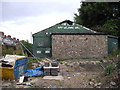
Derelict welfare hall, Sanatorium Rd, Cardiff
Image: © John Lord
Taken: 6 Aug 2010
0.06 miles
2
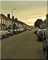
Canton: Lansdowne Road at sunset
Towards the end of a sultry day in July.
Image: © John Sutton
Taken: 12 Jul 2022
0.07 miles
3
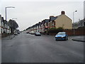
Lansdowne Road approaching Sanatorium Road
Image: © Colin Pyle
Taken: 3 Jan 2011
0.07 miles
4
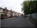
Lansdowne Avenue East, Cardiff
On the other side of the fence on the right is the railway embankment.
Image: © John Lord
Taken: 6 Aug 2010
0.07 miles
5
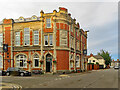
Canton: The Lansdowne
A fine late-Victorian hotel, dated 1898, now a popular pub serving very good food.
Image: © John Sutton
Taken: 12 Jul 2022
0.07 miles
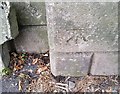
6
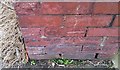
Ordnance Survey Cut Mark
This OS cut mark can be found on No157 Lansdowne Road. It marks a point 7.961m above mean sea level.
Image: © Adrian Dust
Taken: 15 Oct 2017
0.07 miles
7
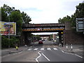
Railway bridges, Sanatorium Rd, Cardiff
The nearer bridge is for the local line, the further for the main line.
Image: © John Lord
Taken: 6 Aug 2010
0.08 miles
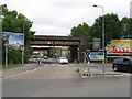
9
Ordnance Survey Cut Mark
This OS cut mark can be found on the SE face of the railway bridge. It marks a point 8.032m above mean sea level.
Image: © Adrian Dust
Taken: 15 Oct 2017
0.11 miles
10

Ordnance Survey Cut Mark
This OS cut mark can be found on No2A Northumberland Street. It marks a point 9.726m above mean sea level.
Image: © Adrian Dust
Taken: 23 Sep 2021
0.12 miles