IMAGES TAKEN NEAR TO
Atlas Place, CARDIFF, CF5 1PG
Introduction
This page details the photographs taken nearby to Atlas Place, CF5 1PG by members of the Geograph project.
The Geograph project started in 2005 with the aim of publishing, organising and preserving representative images for every square kilometre of Great Britain, Ireland and the Isle of Man.

There are currently over 7.5m images from over14,400 individuals and you can help contribute to the project by visiting https://www.geograph.org.uk
Image Map
Images are licensed for reuse under creativecommons.org/licenses/by-sa/2.0
Notes
- Clicking on the map will re-center to the selected point.
- The higher the marker number, the further away the image location is from the centre of the postcode.
Image Listing (102 Images Found)
Images are licensed for reuse under creativecommons.org/licenses/by-sa/2.0
Image
Details
Distance
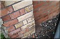
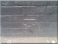
1
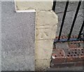
Ordnance Survey Cut Mark
This OS cut mark can be found on No58 Denton Road. It marks a point 8.092m above mean sea level.
Image: © Adrian Dust
Taken: 23 Sep 2021
0.04 miles
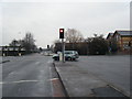
3
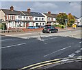
Leckwith Road houses, Cardiff
The broken white lines in the lower right corner of the photo are at the Ninian Park Road junction.
Image: © Jaggery
Taken: 9 Oct 2021
0.08 miles
4
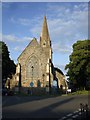
St.John's Church, Canton
Church of St.John the Evangelist, Canton.
Image: © Alan Hughes
Taken: 7 Apr 2016
0.08 miles
5
Ordnance Survey Cut Mark
This OS cut mark can be found on the wall NW side of Bassett Street. It marks a point 8.126m above mean sea level.
Image: © Adrian Dust
Taken: 23 Sep 2021
0.09 miles
6
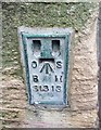
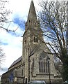
Ordnance Survey Flush Bracket (S1313)
This OS Flush Bracket can be found on the south face of St John's Church. It marks a point 8.289m above mean sea level.
Image: © Adrian Dust
Taken: 15 Oct 2017
0.09 miles
8
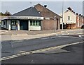
Riverside Cantonese Restaurant, Cardiff
On the corner of Leckwith Road and Ninian Park Road viewed in October 2021.
Mavericks Steak Ranch https://www.geograph.org.uk/photo/3735907 was on this corner in November 2013.
Image: © Jaggery
Taken: 9 Oct 2021
0.11 miles
9
Ordnance Survey Cut Mark
This OS cut mark can be found on No22 Earle Place. It marks a point 7.151m above mean sea level.
Image: © Adrian Dust
Taken: 15 Oct 2017
0.11 miles
10
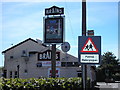
The Ninian park pub
The Ninian park pub, Leckwith road, Cardiff which is named after Cardiff city's ground which is just round the corner. The sign is depicting the goal that made Cardiff city the only non English team to lift the FA cup in 1927.
Image: © Steve Chapple
Taken: 21 Aug 2005
0.11 miles