IMAGES TAKEN NEAR TO
Theobald Road, CARDIFF, CF5 1LP
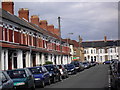
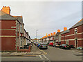
Introduction
This page details the photographs taken nearby to Theobald Road, CF5 1LP by members of the Geograph project.
The Geograph project started in 2005 with the aim of publishing, organising and preserving representative images for every square kilometre of Great Britain, Ireland and the Isle of Man.

There are currently over 7.5m images from over14,400 individuals and you can help contribute to the project by visiting https://www.geograph.org.uk
Image Map
Images are licensed for reuse under creativecommons.org/licenses/by-sa/2.0
Notes
- Clicking on the map will re-center to the selected point.
- The higher the marker number, the further away the image location is from the centre of the postcode.
Image Listing (65 Images Found)
Images are licensed for reuse under creativecommons.org/licenses/by-sa/2.0
Image
Details
Distance
1
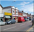
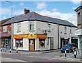
Canton Post Office, Cardiff
Amongst a row of shops on Cowbridge Road East is Canton Post Office, next door to The Canton Cobblers, with a red Royal Mail van parked next to it !
Image: © Jaggery
Taken: 22 Jul 2010
0.04 miles
2
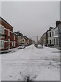
Brunswick St - W from Beda Rd junction
One of Canton's longest streets
Image: © Martin Laverty
Taken: 3 Mar 2018
0.05 miles
3
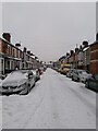
Brunswick St - E from Beda Rd junction
One of Canton's longest streets, this section was built around 1897
Image: © Martin Laverty
Taken: 3 Mar 2018
0.05 miles
4
Canton: Brunswick Street at dusk
Where Theobald Road crosses.
Image: © John Sutton
Taken: 12 Jul 2022
0.06 miles
5
Kaczuszka Polish Shop, Canton, Cardiff
At 220 Cowbridge Road East on the corner of Glamorgan Street.
The cute little yellow duck above the name of the shop is a clue that the Polish word means little duck or duckling. Kaczuszka opened in 2006. The premises were previously Canton Internet Cafe.
Image: © Jaggery
Taken: 22 Jul 2010
0.07 miles
6
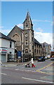
Salem Chapel, Canton, Cardiff
Chapel on Market Road, viewed across Cowbridge Road East. In was built during the first decade of the 20th century.
Image: © Jaggery
Taken: 22 Jul 2010
0.07 miles
7
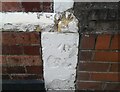
Ordnance Survey Cut Mark
This OS cut mark can be found on No51 Theobald Road. It marks a point 8.705m above mean sea level.
Image: © Adrian Dust
Taken: 23 Sep 2021
0.08 miles
8
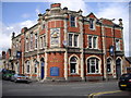
The Lansdowne Hotel, Cardiff
On the corner of Beda Rd and the major road Lansdowne Rd. Road and pub are presumably named after the Marquess of Lansdowne, a prominent politician of the late C19th and early C20th. At the time the pub was built, 1898, he was Secretary of State for War, having previously been Governor General of Canada, then Viceroy of India. What the significance of the beehive/skep sign is, I don't know.
Image: © John Lord
Taken: 1 Aug 2010
0.08 miles
9

Ordnance Survey Cut Mark
This OS cut mark can be found on No2A Northumberland Street. It marks a point 9.726m above mean sea level.
Image: © Adrian Dust
Taken: 23 Sep 2021
0.08 miles