IMAGES TAKEN NEAR TO
Wessex Street, CARDIFF, CF5 1LA
Introduction
This page details the photographs taken nearby to Wessex Street, CF5 1LA by members of the Geograph project.
The Geograph project started in 2005 with the aim of publishing, organising and preserving representative images for every square kilometre of Great Britain, Ireland and the Isle of Man.

There are currently over 7.5m images from over14,400 individuals and you can help contribute to the project by visiting https://www.geograph.org.uk
Image Map
Images are licensed for reuse under creativecommons.org/licenses/by-sa/2.0
Notes
- Clicking on the map will re-center to the selected point.
- The higher the marker number, the further away the image location is from the centre of the postcode.
Image Listing (74 Images Found)
Images are licensed for reuse under creativecommons.org/licenses/by-sa/2.0
Image
Details
Distance
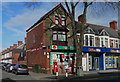
1
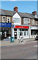
Qi Chinese Medicine Shop, Cardiff
At 380 Cowbridge Road East, between Lionel Road and Turner Road.
Scrabble players whose word source is the Official Tournament & Club Word List are pleased to have 'qi' as the most useful 2-letter word, for playing the potentially awkward letter Q. Qi is defined as "an individual person's life-force, the free flow of which within the body is believed to ensure physical and spiritual health"
Image: © Jaggery
Taken: 22 Jul 2010
0.01 miles
2
Victoria Park Post Office, Cardiff
Shaded on the south side by a tall tree, the post office is at 408 Cowbridge Road East, on the corner of Nesta Road.
Image: © Jaggery
Taken: 22 Jul 2010
0.01 miles
4
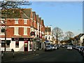
Cowbridge Road East, near Victoria Park
Image: © john bristow
Taken: 17 Feb 2018
0.05 miles
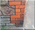
5
Ordnance Survey Cut Mark
This OS cut mark can be found on No503 Cowbridge Road East. It marks a point 8.757m above mean sea level.
Image: © Adrian Dust
Taken: 15 Oct 2017
0.05 miles
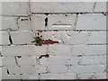
6
Ordnance Survey Cut Mark
This OS cut mark can be found on the building on the SE side of Surrey Street. It marks a point 8.342m above mean sea level.
Image: © Adrian Dust
Taken: 23 Sep 2021
0.05 miles
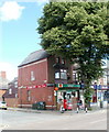
8
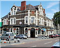
The Victoria Park pub, Cardiff
Pub on the corner of Cowbridge Road East and Kingsland Road. It was built as a hotel at the end of the 19th century.
Image: © Jaggery
Taken: 22 Jul 2010
0.06 miles
9
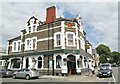
Cardiff - The Victoria Park
Brains pub on the corner of Cowbridge Road East and Kingsland Road which was originally a late 19th century hotel.
Image: © Colin Smith
Taken: 28 Jul 2019
0.06 miles
10
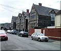
Lansdowne Primary School, Canton, Cardiff
The school occupies 100 metres of the west side of Norfolk Street, nearly the entire length of the street. Opened in 1898 as Lansdowne Road School, it was the largest school built by the Cardiff School Board, designed to accommodate 1480 pupils.
Image: © Jaggery
Taken: 22 Jul 2010
0.06 miles