IMAGES TAKEN NEAR TO
Regina Terrace, CARDIFF, CF5 1GJ
Introduction
This page details the photographs taken nearby to Regina Terrace, CF5 1GJ by members of the Geograph project.
The Geograph project started in 2005 with the aim of publishing, organising and preserving representative images for every square kilometre of Great Britain, Ireland and the Isle of Man.

There are currently over 7.5m images from over14,400 individuals and you can help contribute to the project by visiting https://www.geograph.org.uk
Image Map
Images are licensed for reuse under creativecommons.org/licenses/by-sa/2.0
Notes
- Clicking on the map will re-center to the selected point.
- The higher the marker number, the further away the image location is from the centre of the postcode.
Image Listing (62 Images Found)
Images are licensed for reuse under creativecommons.org/licenses/by-sa/2.0
Image
Details
Distance
2
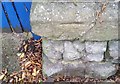
Ordnance Survey Cut Mark
This OS cut mark can be found on the wall of No98 Clive Road. It marks a point 18.169m above mean sea level.
Image: © Adrian Dust
Taken: 15 Oct 2017
0.04 miles
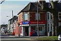
4
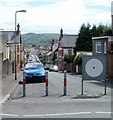
Conybeare Road, Cardiff
The view from Pencisely Road.
On the other side of the large white circle is a No Entry sign. Presumably metal posts similar to those on its left would have done the same job.
Image: © Jaggery
Taken: 22 Jul 2010
0.05 miles
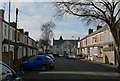
6
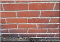
Ordnance Survey Cut Mark
This OS cut mark can be found on No15 Burlington Terrace. It marks a point 14.405m above mean sea level.
Image: © Adrian Dust
Taken: 15 Oct 2017
0.09 miles
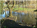
7
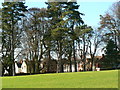
Thompson's Park
The houses in the background are on Syr David Avenue.
Image: © john bristow
Taken: 7 Mar 2014
0.10 miles
10

Syr David's Ave & entrance to Thompson's Park, Llandaff
Syr David's Ave. is a quiet cul-de-sac where I had lodgings in 1963, the first of my three years studying at WCAT (Welsh College of Advanced Technology). I believe the college later became part of the university.
Image: © Mike Dodman
Taken: 16 Jul 2010
0.10 miles