IMAGES TAKEN NEAR TO
Westbury Terrace, CARDIFF, CF5 1FZ
Introduction
This page details the photographs taken nearby to Westbury Terrace, CF5 1FZ by members of the Geograph project.
The Geograph project started in 2005 with the aim of publishing, organising and preserving representative images for every square kilometre of Great Britain, Ireland and the Isle of Man.

There are currently over 7.5m images from over14,400 individuals and you can help contribute to the project by visiting https://www.geograph.org.uk
Image Map
Images are licensed for reuse under creativecommons.org/licenses/by-sa/2.0
Notes
- Clicking on the map will re-center to the selected point.
- The higher the marker number, the further away the image location is from the centre of the postcode.
Image Listing (46 Images Found)
Images are licensed for reuse under creativecommons.org/licenses/by-sa/2.0
Image
Details
Distance
1
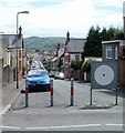
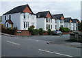
Conybeare Road, Cardiff
The view from Pencisely Road.
On the other side of the large white circle is a No Entry sign. Presumably metal posts similar to those on its left would have done the same job.
Image: © Jaggery
Taken: 22 Jul 2010
0.05 miles
2
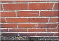
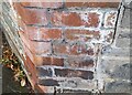
Ordnance Survey Cut Mark
This OS cut mark can be found on No15 Burlington Terrace. It marks a point 14.405m above mean sea level.
Image: © Adrian Dust
Taken: 15 Oct 2017
0.07 miles
3
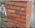
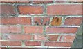
Ordnance Survey Cut Mark
This damaged and moved OS cut mark can be found on the gatepost of No19 Chargot Road. It marked a point 9.092m above mean sea level.
Image: © Adrian Dust
Taken: 23 Sep 2021
0.09 miles
4
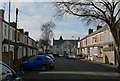
West side of Greenwich Road, Cardiff
Viewed from Pencisely Road.
Image: © Jaggery
Taken: 22 Jul 2010
0.09 miles
5
Greenwich Road, Cardiff
Houses on the east side of Greenwich Road, viewed from Pencisely Road.
Image: © Jaggery
Taken: 22 Jul 2010
0.09 miles
6
Ordnance Survey Cut Mark
This OS cut mark can be found on the wall NE side of Pencisely Road. It marks a point 16.554m above mean sea level.
Image: © Adrian Dust
Taken: 23 Sep 2021
0.11 miles
7
Ordnance Survey Cut Mark
This damaged OS cut mark can be found on the wall of Nos75 & 77 Pencisely Road. It marks a point 20.879m above mean sea level.
Image: © Adrian Dust
Taken: 15 Oct 2017
0.11 miles
9
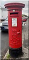
Edward VII postbox
Located in Romilly Road West.
Image: © Alan Hughes
Taken: 29 Sep 2022
0.11 miles
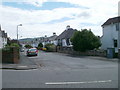
10
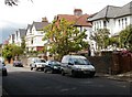
Palace Road, Cardiff
The SE end of Palace Road, viewed from the corner of Pencisely Road.
Image: © Jaggery
Taken: 22 Jul 2010
0.12 miles