IMAGES TAKEN NEAR TO
CF4 8NA
Introduction
This page details the photographs taken nearby to CF4 8NA by members of the Geograph project.
The Geograph project started in 2005 with the aim of publishing, organising and preserving representative images for every square kilometre of Great Britain, Ireland and the Isle of Man.

There are currently over 7.5m images from over14,400 individuals and you can help contribute to the project by visiting https://www.geograph.org.uk
Image Map
Images are licensed for reuse under creativecommons.org/licenses/by-sa/2.0
Notes
- Clicking on the map will re-center to the selected point.
- The higher the marker number, the further away the image location is from the centre of the postcode.
Image Listing (7 Images Found)
Images are licensed for reuse under creativecommons.org/licenses/by-sa/2.0
Image
Details
Distance
1
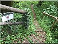
Coed y Bedw Nature Reserve
Track through Coed y Bedw Nature Reserve.
Image: © Alan Hughes
Taken: 8 Jun 2016
0.17 miles
2
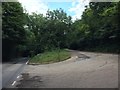
Road Junction
Junction of Quarry track with Heol Goch near Pentyrch.
Image: © Alan Hughes
Taken: 12 Jul 2017
0.19 miles
3
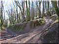
Old track
This old track connects Gwaelod-y-garth and Efail Isaf.
Image: © Alan Hughes
Taken: 13 Aug 2019
0.23 miles
5
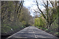
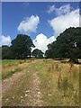
Heol Goch - Pentyrch
The wooded route between Taff's Well and Pentyrch.
Image: © Mick Lobb
Taken: 20 Apr 2010
0.24 miles
6
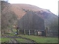
Remains of Caerwen Farm
The wall looks in quite good condition for a ruin - unfortunately it is all that is left of the building! The eastern end of Garth Hill can be seen in the background.
Image: © John Light
Taken: 28 Jan 2010
0.25 miles
7
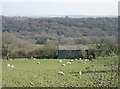
Field of Sheep
Looking southeast across a field of sheep towards Heol Goch and the Skyline of Cardiff in the distance.
Image: © Peter Wasp
Taken: 4 Apr 2007
0.25 miles