
IMAGES TAKEN NEAR TO
Dowlais, MERTHYR TYDFIL, CF48 2YG
Introduction
This page details the photographs taken nearby to CF48 2YG by members of the Geograph project.
The Geograph project started in 2005 with the aim of publishing, organising and preserving representative images for every square kilometre of Great Britain, Ireland and the Isle of Man.

There are currently over 7.5m images from over14,400 individuals and you can help contribute to the project by visiting https://www.geograph.org.uk
Image Map
Images are licensed for reuse under creativecommons.org/licenses/by-sa/2.0
Notes
- Clicking on the map will re-center to the selected point.
- The higher the marker number, the further away the image location is from the centre of the postcode.
Image Listing (17 Images Found)
Images are licensed for reuse under creativecommons.org/licenses/by-sa/2.0
Image
Details
Distance
1
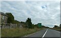
Distance board on A465 east of Dowlais Top
Image: © David Smith
Taken: 21 Sep 2022
0.03 miles
4
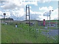
Pengarnddu bridge, Dowlais Top
This walking and cycling bridge was opened on 7th December 2011.
It is on the Heads of the Valleys section of National Cycle Route 46.
Image: © Robin Drayton
Taken: 18 Jun 2012
0.15 miles
5
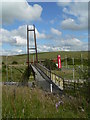
Footbridge at Pengarnddu, Merthyr Tydfil
This newly constructed footbridge takes pedestrians and cyclists over the road to Pengarnddu Industrial Estate and Fochriw. This view is from the edge of the Asda car park.
Image: © Colin Cheesman
Taken: 2 Aug 2012
0.15 miles
6

Asda Superstore interior, Dowlais Top, Merthyr Tydfil
Image: © Robin Drayton
Taken: 3 Jan 2013
0.16 miles
7

Boundary sign on a minor road near to Dowlais Top
This border is between the principal areas http://en.wikipedia.org/wiki/Local_government_in_Wales of the County Boroughs of Caerphilly and Merthyr Tydfil.
The eastbound carriageway of the A465 Heads of the Valleys road is visible between the supports of the sign.
The huge bank of earth to the left was constructed when the A465 was dualled to the east of this point in 2004 in anticipation of a flyover at Dowlais Top when dualling to the west of this point is implemented.
Image: © Robin Drayton
Taken: 3 Aug 2013
0.17 miles
8

Caerphilly County Borough boundary sign on A465 eastbound
Image: © Colin Pyle
Taken: 7 May 2012
0.17 miles
9

Wilderness eastward, near site of Dowlais Top station, 1990
View ESE on the road to Fochriw, just off the Heads of the Valleys road. The wagon-body across the small reservoir (?dried up) was the only railway remnant. Nowadays, 25 years later, all is totally changed, with a complex of roads - even an artificial hill, but the mountain (Twyn-y-Waun, 1,474 ft.)) is still there.
Image: © Ben Brooksbank
Taken: 20 May 1990
0.17 miles
10

Wilderness near site of Dowlais Top station, 1990
View NE, just off the Heads of the Valleys Road on the road to Fochriw, at the same site as Image My car and a tractor wait, - and there is water in the reservoir. In the distance are the Mynydd Llangynidr, rising to 1,800 ft.
Image: © Ben Brooksbank
Taken: 20 May 1990
0.17 miles