
IMAGES TAKEN NEAR TO
Pearces Court, MERTHYR TYDFIL, CF48 2PP
Introduction
This page details the photographs taken nearby to Pearces Court, CF48 2PP by members of the Geograph project.
The Geograph project started in 2005 with the aim of publishing, organising and preserving representative images for every square kilometre of Great Britain, Ireland and the Isle of Man.

There are currently over 7.5m images from over14,400 individuals and you can help contribute to the project by visiting https://www.geograph.org.uk
Image Map
Images are licensed for reuse under creativecommons.org/licenses/by-sa/2.0
Notes
- Clicking on the map will re-center to the selected point.
- The higher the marker number, the further away the image location is from the centre of the postcode.
Image Listing (109 Images Found)
Images are licensed for reuse under creativecommons.org/licenses/by-sa/2.0
Image
Details
Distance
1
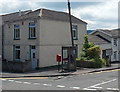
Postbox and phonebox on a High Street corner in Cefn-coed-y-cymmer
On the corner of Pearce's Court near the NW end of High Street.
Image: © Jaggery
Taken: 16 Jun 2014
0.02 miles
2
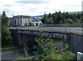
Bridge over the Heads of the Valleys Road, Cefn-coed-y-cymmer
The A4054 crosses above the A465 Heads of the Valleys Road.
High Street Cefn-coed-y-cymmer is in the background.
Image: © Jaggery
Taken: 16 Jun 2014
0.02 miles
3
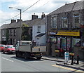
Cefn Convenience Store & Bakery, Cefn-coed-y-cymmer
A Premier store in High Street.
Image: © Jaggery
Taken: 16 Jun 2014
0.02 miles
4
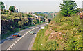
Eastward on Heads of the Valleys road at Cefn-y-Coed-y-Cymmer
View eastwards from High Street bridge over new A465(T).
Image: © Ben Brooksbank
Taken: 20 May 1990
0.02 miles
5
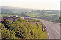
Southwest on Heads of the Valleys Road at Cefn-y-Coed-y-Cymmer, 1990
As Image but view westward over Afon Taf Fawr valley.
Image: © Ben Brooksbank
Taken: 20 May 1990
0.02 miles
6
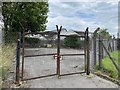
Gated yard
Yard protected by barbed wire and rusty old gates.
Image: © Alan Hughes
Taken: 31 Jul 2020
0.03 miles
7

Cefn-y-Coed-y-Cymmer: High Street, 1990
View down High Street towards Merthyr Tydfil, from the bridge over the Heads of the Valleys road.
Image: © Ben Brooksbank
Taken: 20 May 1990
0.04 miles
8
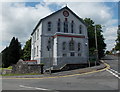
East side of Tabor Chapel, Cefn-coed-y-cymmer
On the corner of the A4054 Upper High Street and Grawen Lane.
The inscription shows that Tabor was built in 1845, rebuilt in 1904.
Image: © Jaggery
Taken: 16 Jun 2014
0.04 miles
9
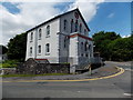
SW side of Tabor Chapel, Cefn-coed-y-cymmer
On the corner of the A4054 Upper High Street and Grawen Lane.
The inscription shows that Tabor was built in 1845, rebuilt in 1904.
Image: © Jaggery
Taken: 16 Jun 2014
0.04 miles
10
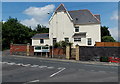
A470 distances from Cefn-coed-y-cymmer
Viewed from Grawen Lane, opposite Tabor Chapel. http://www.geograph.org.uk/photo/4032756 Turn left for Brecon (17 miles) or right for Merthyr Tydfil (2 miles). The right turn is also the way to Prince Charles Hospital.
Image: © Jaggery
Taken: 16 Jun 2014
0.04 miles