
IMAGES TAKEN NEAR TO
Cloth Hall Lane, MERTHYR TYDFIL, CF48 2NT
Introduction
This page details the photographs taken nearby to Cloth Hall Lane, CF48 2NT by members of the Geograph project.
The Geograph project started in 2005 with the aim of publishing, organising and preserving representative images for every square kilometre of Great Britain, Ireland and the Isle of Man.

There are currently over 7.5m images from over14,400 individuals and you can help contribute to the project by visiting https://www.geograph.org.uk
Image Map
Images are licensed for reuse under creativecommons.org/licenses/by-sa/2.0
Notes
- Clicking on the map will re-center to the selected point.
- The higher the marker number, the further away the image location is from the centre of the postcode.
Image Listing (54 Images Found)
Images are licensed for reuse under creativecommons.org/licenses/by-sa/2.0
Image
Details
Distance
1
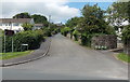
Cloth Hall Lane, Cefn-coed-y-cymmer
On the left, a brown sign showing Merthyr Tydfil Golf Club points along Cloth Hall Lane.
Image: © Jaggery
Taken: 16 Jun 2014
0.09 miles
2
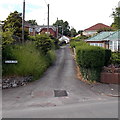
Vaynor Lane, Cefn-coed-y-cymmer
Vaynor Lane is a 70 metre long dead-end lane on the NW side of Vaynor Road.
Image: © Jaggery
Taken: 16 Jun 2014
0.10 miles
3
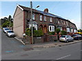
Vaynor Villas, Cefn-coed-y-cymmer
The Vaynor Villas name sign is on the wall of Upper Vaynor Road,
centre right, on the corner of Somerset Lane on the left.
Image: © Jaggery
Taken: 16 Jun 2014
0.14 miles
4
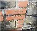
Ordnance Survey Cut Mark
This OS cut mark can be found on the wall of No1 Vaynor Road. It marks a point 241.103m above mean sea level.
Image: © Adrian Dust
Taken: 12 Mar 2021
0.14 miles
5
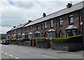
Upper Vaynor Road houses, Cefn-coed-y-cymmer
The row of houses extends for 85 metres, ending at the corner of Somerset Lane.
Image: © Jaggery
Taken: 16 Jun 2014
0.14 miles
6
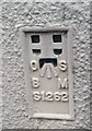
Ordnance Survey Flush Bracket (S1262)
This OS Flush Bracket can be found on the house 'Woody Bank'. It marks a point 247.324m above mean sea level.
Image: © Adrian Dust
Taken: 12 Mar 2021
0.14 miles
7

Llwybr Taf / Taff Trail
Cerddwyr yn dilyn Llwybr Taf a oedd yn gynt Rheilffordd Aberhonddu & Merthyr.
Walkers following the Taff Trail which was formerly the Brecon & Merthyr Railway.
Image: © Alan Richards
Taken: 27 Jul 2014
0.14 miles
8
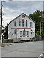
Tabor chapel
Welsh independent chapel in Cefn Coed.
Image: © Alan Hughes
Taken: 31 Jul 2020
0.15 miles
9
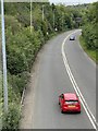
Heads of the Valleys road
A465 from Neath to Abergavenny.
Image: © Alan Hughes
Taken: 31 Jul 2020
0.16 miles
10
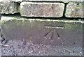
Ordnance Survey Cut Mark
This OS cut mark can be found on the gatepost of Ashville. It marks a point 249.512m above mean sea level.
Image: © Adrian Dust
Taken: 12 Mar 2021
0.16 miles