IMAGES TAKEN NEAR TO
Heol-y-Castell, MERTHYR TYDFIL, CF48 2DF
Introduction
This page details the photographs taken nearby to Heol-y-Castell, CF48 2DF by members of the Geograph project.
The Geograph project started in 2005 with the aim of publishing, organising and preserving representative images for every square kilometre of Great Britain, Ireland and the Isle of Man.

There are currently over 7.5m images from over14,400 individuals and you can help contribute to the project by visiting https://www.geograph.org.uk
Image Map
Images are licensed for reuse under creativecommons.org/licenses/by-sa/2.0
Notes
- Clicking on the map will re-center to the selected point.
- The higher the marker number, the further away the image location is from the centre of the postcode.
Image Listing (19 Images Found)
Images are licensed for reuse under creativecommons.org/licenses/by-sa/2.0
Image
Details
Distance
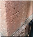
1
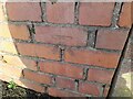
Ordnance Survey Cut Mark
This OS cut mark can be found on the wall at the junction of Heol y Castell & Heol Bryniau. It marks a point 376.835m above mean sea level.
Image: © Adrian Dust
Taken: 2 Jan 2023
0.02 miles
2
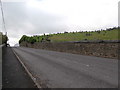
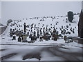
The road past Pant Cemetery
Crosses and headstones are silhouetted on the skyline. The bus route was deceptive; although there was a bus stop on either side of the road, buses appeared only to travel along the road in one direction (uphill).
Image: © HelenK
Taken: 25 Sep 2017
0.04 miles
3
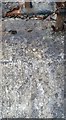
Ordnance Survey Rivet
This OS rivet can be found on the wall at the south entrance of Pant Cemetery. It marks a point 340.739m above mean sea level.
Image: © Adrian Dust
Taken: 30 Oct 2019
0.05 miles
8
Ordnance Survey Cut Mark
This OS cut mark can be found on the railway buttress. It marks a point 334.360m above mean sea level.
Image: © Adrian Dust
Taken: 2 Jan 2023
0.11 miles
9
Ordnance Survey Cut Mark
This OS cut mark can be found on Pantysgalleg House, Pant Road. It marks a point 333.704m above mean sea level.
Image: © Adrian Dust
Taken: 30 Oct 2019
0.11 miles
10
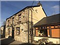
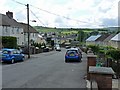
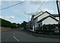
Y Pant Cad Ifor
A pub on the outskirts of Merthyr Tydfil.
Image: © Alan Hughes
Taken: 9 Jan 2019
0.11 miles