IMAGES TAKEN NEAR TO
Heolgerrig, MERTHYR TYDFIL, CF48 1RS
Introduction
This page details the photographs taken nearby to CF48 1RS by members of the Geograph project.
The Geograph project started in 2005 with the aim of publishing, organising and preserving representative images for every square kilometre of Great Britain, Ireland and the Isle of Man.

There are currently over 7.5m images from over14,400 individuals and you can help contribute to the project by visiting https://www.geograph.org.uk
Image Map
Images are licensed for reuse under creativecommons.org/licenses/by-sa/2.0
Notes
- Clicking on the map will re-center to the selected point.
- The higher the marker number, the further away the image location is from the centre of the postcode.
Image Listing (23 Images Found)
Images are licensed for reuse under creativecommons.org/licenses/by-sa/2.0
Image
Details
Distance
1
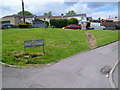
Mount Pleasant leading to Tramroadside, Heolgerrig, Merthyr Tydfil
The sign is at the southern edge of a grassy triangle.
Image: © Jaggery
Taken: 13 Jun 2012
0.05 miles
2
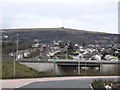
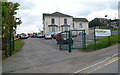
Heolgerrig preceded by A470
Taken from a recently developed retail park, this pic shows over The A470 Trunk road Heolgerrig and beyond to Mynydd Aberdar And one of its transmitters Image
Image: © Bonelli
Taken: Unknown
0.06 miles
3
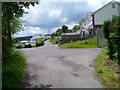
A fork in the road, Mount Pleasant, Heolgerrig, Merthyr Tydfil
Looking south from the edge of Tramroadside.
Image: © Jaggery
Taken: 13 Jun 2012
0.06 miles
4
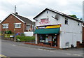
Heol Gerrig Stores, Heolgerrig, Merthyr Tydfil
A Premier store on the corner of Farm Road and Heolgerrig.
Image: © Jaggery
Taken: 13 Jun 2012
0.08 miles
5
Heolgerrig Social Club and Alpha House, Heolgerrig, Merthyr Tydfil
Located on the corner of Heolgerrig and Cwmglo Road.
Alpha House is located on the right of, and behind, Heolgerrig Social Club. It is the meeting place of Nation Changers Church. Their banner is on the fence in the foreground.
Image: © Jaggery
Taken: 13 Jun 2012
0.08 miles
6
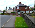
Houses at the NW end of Brondeg, Heolgerrig, Merthyr Tydfil
Viewed from the corner of Heolgerrig, the main road through the Merthyr Tydfil district also named Heolgerrig.
Image: © Jaggery
Taken: 13 Jun 2012
0.08 miles
7
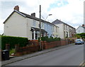
Meirion Place, Heolgerrig, Merthyr Tydfil
Meirion Place is the row of three houses in the foreground. Behind them is Danyronen, also a row of three houses.
Image: © Jaggery
Taken: 13 Jun 2012
0.08 miles
8
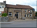
Six Bells Inn, Heolgerrig, Merthyr Tydfil
Faded text on the nameboard shows ON THE SITE OF THE FAMOUS HEOLGERRIG BREWERY.
The Heolgerrig brewery was built by Evans Evans alongside the original Six Bells, which was in a field on the opposite side of the road from the present-day Six Bells.
Image: © Jaggery
Taken: 13 Jun 2012
0.09 miles
9
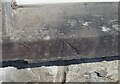
Ordnance Survey Pivot
This OS pivot can be found on the window sill of No73 Heol Cerrig. It marks a point 259.164m above mean sea level.
Image: © Adrian Dust
Taken: 8 Jul 2021
0.12 miles
10
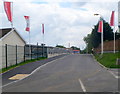
Cwmglo Road, Heolgerrig, Merthyr Tydfil
Redrow (a house building and general construction company) flags line the road leading to their new housing development.
Image: © Jaggery
Taken: 13 Jun 2012
0.14 miles