IMAGES TAKEN NEAR TO
Glebeland Place, MERTHYR TYDFIL, CF47 8TJ
Introduction
This page details the photographs taken nearby to Glebeland Place, CF47 8TJ by members of the Geograph project.
The Geograph project started in 2005 with the aim of publishing, organising and preserving representative images for every square kilometre of Great Britain, Ireland and the Isle of Man.

There are currently over 7.5m images from over14,400 individuals and you can help contribute to the project by visiting https://www.geograph.org.uk
Image Map
Images are licensed for reuse under creativecommons.org/licenses/by-sa/2.0
Notes
- Clicking on the map will re-center to the selected point.
- The higher the marker number, the further away the image location is from the centre of the postcode.
Image Listing (227 Images Found)
Images are licensed for reuse under creativecommons.org/licenses/by-sa/2.0
Image
Details
Distance
1
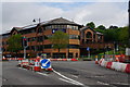
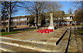
Glebeland Place, Merthyr Tydfil
Viewed across the Avenue de Clichy.
Salvation Army Citadel http://www.geograph.org.uk/photo/1826252 on the left, council offices on the right.
Image: © Jaggery
Taken: 16 Jun 2014
0.01 miles
2
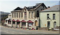
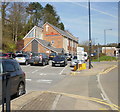
Fire-damaged building, Bethesda Street, Merthyr Tydfil
On December 28th 2009, fire severely damaged an unoccupied building on Bethesda Street, formerly known as RM’s Rock Club. The two-storey building had been sold earlier in the month to an undisclosed purchaser.
The club holds happy memories for music fans throughout the South Wales valleys, and inspired many musicians over the years. In its heyday, RM’s Rock Club – based in the upstairs nightclub – was the place to be for up and coming bands, who came from far and wide to play to the crowds. But the rock club closed at the end of 2005, because of dwindling public support.
Over the years the downstairs section has had various uses, including Bethesda Brasserie, a Chinese restaurant, and a Fun Pub. The club itself had run under a number of names including Shooters, Barnies, and NV.
Image: © Jaggery
Taken: 21 Apr 2010
0.04 miles
3
Great War soldier silhouette in Merthyr Tydfil town centre
Located at the edge of this https://www.geograph.org.uk/photo/6169273 War Memorial. The Royal British Legion sign shows
1914-1918 Lest We Forget and its Welsh equivalent.
Image: © Jaggery
Taken: 27 Feb 2019
0.04 miles
4
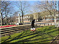
War Memorial in Merthyr Tydfil town centre
The Celtic Cross is on the corner of Castle Street and Glebeland Place.
Image: © Jaggery
Taken: 27 Feb 2019
0.04 miles
5
Salvation Army Citadel, Merthyr Tydfil
In 1878 two young evangelists arrived in Merthyr Tydfil for the purpose of establishing a branch of a new religious organisation known as the Christian Mission. The organisation was later renamed the Salvation Army. In the early years, various premises were used. The Salvation Army's current citadel in Glebeland Place, shown here, opened in 1937 and has since been extensively modernised.
Image: © Jaggery
Taken: 21 Apr 2010
0.06 miles
6
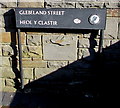
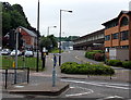
Bilingual name sign at the western end of Glebeland Street, Merthyr Tydfil
Glebeland Street is Heol y Clastir in Welsh. Merthyr Tydfil is Merthyr Tudful in Welsh
Image: © Jaggery
Taken: 27 Feb 2019
0.07 miles
7
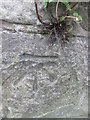
Ordnance Survey Cut Mark
This OS cut mark can be found on the steps wall leading to Abermorlais Terrace. It marks a point 189.857m above mean sea level.
Image: © Adrian Dust
Taken: 13 Jun 2015
0.07 miles
8
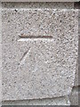
Ordnance Survey Cut Mark
This OS cut mark can be found on the front of Taf Fechan Water Supply Board Offices (built 1932). It marks a point 176.114m above mean sea level.
Image: © Adrian Dust
Taken: 13 Jun 2015
0.07 miles
9
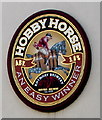
Hobbyhorse sign on the wall of the Winchester Bar, Merthyr Tydfil
Rhymney Brewery sign on the wall here. https://www.geograph.org.uk/photo/3000938
Image: © Jaggery
Taken: 27 Feb 2019
0.07 miles