1
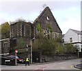
Church Street, Thomastown
The facade of the Miners' Hall stands on Church Street, formerly Shiloh Welsh Wesleyan Chapel. http://www.merthyr-history.com/?p=936 It was destroyed by fire in 1992.
Image: © Eirian Evans
Taken: 22 Jul 2019
0.02 miles
2
Ordnance Survey Cut Mark
This heavily painted OS cut mark can be found on the front of the Brunswick Hotel, Church Street. It marks a point 184.7271m above mean sea level.
Image: © Adrian Dust
Taken: 27 Apr 2014
0.02 miles
3
Ordnance Survey Cut Mark
This OS cut mark can be found on the Brunswich Hotel. It marks a point 184.727m above mean sea level.
Image: © Adrian Dust
Taken: 29 Oct 2017
0.02 miles
4
Miners' Hall, Merthyr Tydfil
As I was taking the photo, a passer-by expressed in strong terms her disgust at a) the unsightliness of the ruin and b) the misspelling of the street name in front of it, Heol-yr-Reglwys instead of Heol-yr-Eglwys (Church St, for non-Welsh speakers).
Image: © John Lord
Taken: 1 Feb 2012
0.02 miles
5
Ordnance Survey Cut Mark
This OS cut mark can be found on the wall of the Miner's Hall, Church Street. It marks a point 180.4386m above mean sea level.
Image: © Adrian Dust
Taken: 27 Apr 2014
0.03 miles
6
Miners Hall, Merthyr Tudful
Originally known as Shiloh Chapel, it changed use to become a miners' welfare hall.
Image: © Chris Andrews
Taken: 20 Nov 2014
0.03 miles
7
Former Unitarian Church, Merthyr Tydfil
Image: © John Lord
Taken: 1 Feb 2012
0.03 miles
8
The Miners Arms
A town centre pub situated in the basement of a ruined church, on Church Street, Merthyr Tydfil.
Image: © Jonathan Billinger
Taken: 14 Mar 2008
0.03 miles
9
Miners Hall, Merthyr Tydfil
The former Miner's Welfare Hall is believed to have been designed by Isambard Kingdom Brunel but was severely damaged by fire sometime in the past. It was Grade II listed on 13 January 1988.
Image: © Richard Rogerson
Taken: 31 Jan 2011
0.05 miles
10
Ordnance Survey Cut Mark
This OS cut mark can be found on No21 Lower Thomas Street. It marks a point 180.807m above mean sea level.
Image: © Adrian Dust
Taken: 29 Oct 2017
0.06 miles


