IMAGES TAKEN NEAR TO
Warren Terrace, TREHARRIS, CF46 6DL
Introduction
This page details the photographs taken nearby to Warren Terrace, CF46 6DL by members of the Geograph project.
The Geograph project started in 2005 with the aim of publishing, organising and preserving representative images for every square kilometre of Great Britain, Ireland and the Isle of Man.

There are currently over 7.5m images from over14,400 individuals and you can help contribute to the project by visiting https://www.geograph.org.uk
Image Map
Images are licensed for reuse under creativecommons.org/licenses/by-sa/2.0
Notes
- Clicking on the map will re-center to the selected point.
- The higher the marker number, the further away the image location is from the centre of the postcode.
Image Listing (46 Images Found)
Images are licensed for reuse under creativecommons.org/licenses/by-sa/2.0
Image
Details
Distance
4
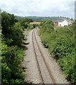
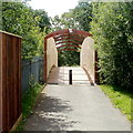
Railway between two bridges, Trelewis
Viewed from this http://www.geograph.org.uk/photo/3159746 road bridge looking towards a railway footbridge 180 metres ahead.
The railway is for freight only.
Image: © Jaggery
Taken: 24 May 2011
0.04 miles
5
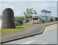
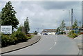
Southern boundary of Trelewis
The road north from Nelson reaches the boundary of Trelewis, in the southern part of Merthyr Tydfil County Borough. The black boundary sign is between a bus shelter and a stone structure whose significance is unknown to this contributor.
Image: © Jaggery
Taken: 24 May 2011
0.05 miles
6
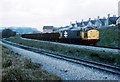
Coal from Cwm Bargoed
Approaching the Junction at Nelson and Llancaiach this train has come to a stand.
The line in the foreground once went to Deep Navigation Mine and Trelewis. This was a busy location with the movement of coal and shale. Nowadays only the line to Cwm Bargoed is left with infrequent trains.
Image: © roger geach
Taken: 9 Apr 1987
0.05 miles
7
Footbridge over a railway, Trelewis
See http://www.geograph.org.uk/photo/88545 for a side view and some details.
Image: © Jaggery
Taken: 24 May 2011
0.05 miles
8
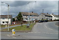
Gelligaer Road, Trelewis
A sign in a grass triangle points right along the B4524 towards Gelligaer, 1¾ miles ahead.
Image: © Jaggery
Taken: 24 May 2011
0.06 miles
9
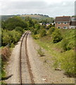
Railway line heads north into Trelewis
Viewed from this http://www.geograph.org.uk/photo/3159849 footbridge. The railway is for freight only. There were formerly two
railway stations in Trelewis, Trelewis Halt and Trelewis Platform. Both closed in 1964.
Image: © Jaggery
Taken: 24 May 2011
0.06 miles
10
Southern boundary of Merthyr Tydfil County Borough
More than 10km south of the town of Merthyr Tydfil, the road from Nelson in Caerphilly County Borough crosses into the County Borough of Merthyr Tydfil.
The Trelewis boundary sign http://www.geograph.org.uk/photo/3159816 is a few metres ahead.
Image: © Jaggery
Taken: 24 May 2011
0.07 miles