IMAGES TAKEN NEAR TO
Market Close, TREHARRIS, CF46 6AZ
Introduction
This page details the photographs taken nearby to Market Close, CF46 6AZ by members of the Geograph project.
The Geograph project started in 2005 with the aim of publishing, organising and preserving representative images for every square kilometre of Great Britain, Ireland and the Isle of Man.

There are currently over 7.5m images from over14,400 individuals and you can help contribute to the project by visiting https://www.geograph.org.uk
Image Map
Images are licensed for reuse under creativecommons.org/licenses/by-sa/2.0
Notes
- Clicking on the map will re-center to the selected point.
- The higher the marker number, the further away the image location is from the centre of the postcode.
Image Listing (222 Images Found)
Images are licensed for reuse under creativecommons.org/licenses/by-sa/2.0
Image
Details
Distance
1
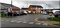
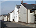
Market Close, Nelson
Cul-de-sac of 21st century houses viewed across the B4255 Commercial Street.
Bilingual street name signs show that Market Close is Clos y Farchnad in Welsh.
Nelson Public Library and Learning Centre https://www.geograph.org.uk/photo/6004623 is on the left.
Image: © Jaggery
Taken: 20 Dec 2018
0.01 miles
2
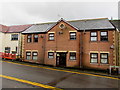
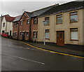
Six flats, Heol Fawr, Nelson
Six letterboxes are alongside the front door.
Image: © Jaggery
Taken: 20 Dec 2018
0.03 miles
3
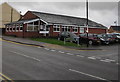
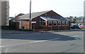
Nelson Public Library and Learning Centre
Located on the corner of Commercial Street and Market Close, part of Caerphilly County Borough's library service.
The bilingual street name sign shows that Market Close is Clos y Farchnad in Welsh.
Image: © Jaggery
Taken: 20 Dec 2018
0.03 miles
4
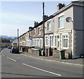
Caerphilly Road houses, Nelson
Houses on the north side of Caerphilly Road. In the distance is Commercial Street.
Image: © Jaggery
Taken: 17 Mar 2011
0.03 miles
5
Heol Fawr houses, Nelson
Houses on the east side of a road named Heol Fawr, between Tylers Arms http://www.geograph.org.uk/photo/2318445 (behind the camera) and the junction with Caerphilly Road and Commercial Street.
Image: © Jaggery
Taken: 17 Mar 2011
0.03 miles
6
Nelson Library
Located on Commercial Street, the Library and Learning Centre are part of Caerphilly County Borough's library service.
Image: © Jaggery
Taken: 17 Mar 2011
0.03 miles
7
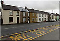
Dynevor Terrace houses in Nelson
On the east side of the B4255 Dynevor Terrace viewed from Nelson Bus Station.
Image: © Jaggery
Taken: 20 Dec 2018
0.03 miles
8
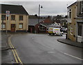
Bend in the B4255 in Nelson
On the descent to the centre of Nelson, the B4255 Caerphilly Road on the camera side becomes the B4255 Commercial Street at the Heol Fawr junction on the left.
Image: © Jaggery
Taken: 20 Dec 2018
0.03 miles
9
Houses at the southern end of Heol Fawr, Nelson
Viewed from the B4255 junction in December 2018. The house on
the left is recently built - it is not in a May 2016 Google Street View.
Image: © Jaggery
Taken: 20 Dec 2018
0.03 miles
10
Ordnance Survey Cut Mark
This OS cut mark can be found on the Take-Away at the junction of Caerphilly Road & Heol Fawr. It marks a point 155.326m above mean sea level.
Image: © Adrian Dust
Taken: 25 May 2019
0.04 miles