IMAGES TAKEN NEAR TO
Brynteg, TREHARRIS, CF46 5RE
Introduction
This page details the photographs taken nearby to Brynteg, CF46 5RE by members of the Geograph project.
The Geograph project started in 2005 with the aim of publishing, organising and preserving representative images for every square kilometre of Great Britain, Ireland and the Isle of Man.

There are currently over 7.5m images from over14,400 individuals and you can help contribute to the project by visiting https://www.geograph.org.uk
Image Map
Images are licensed for reuse under creativecommons.org/licenses/by-sa/2.0
Notes
- Clicking on the map will re-center to the selected point.
- The higher the marker number, the further away the image location is from the centre of the postcode.
Image Listing (49 Images Found)
Images are licensed for reuse under creativecommons.org/licenses/by-sa/2.0
Image
Details
Distance
1
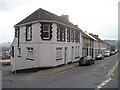
Brynteg, Treharris
The long row of houses is on Brynteg, Cardiff Road (B4254). The nearest house is on the corner of the southern section of a road named The Park.
Image: © Jaggery
Taken: 17 Mar 2011
0.03 miles
2
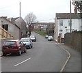
The Park, Treharris
The Park climbs away from Cardiff Road (B4254). The grey wall on the right is the perimeters of St Matthias church. http://www.geograph.org.uk/photo/2311630
Image: © Jaggery
Taken: 17 Mar 2011
0.03 miles
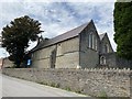
3
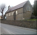
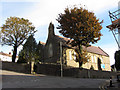
St Matthias Church, Treharris
Church in Wales church (diocese of Llandaff), located on the corner of Cardiff Road (B4254) and The Park. The church was built in 1896. The church name board shows
The Parish of Treharris, Trelewis and Bedlinog
'Growing in Faith'
St. Matthias Church.
Image: © Jaggery
Taken: 17 Mar 2011
0.03 miles
4
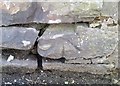
Ordnance Survey Cut Mark
This OS cut mark can be found on the wall south side of Commercial Terrace. It marks a point 158.908m above mean sea level.
Image: © Adrian Dust
Taken: 14 Apr 2018
0.03 miles
5
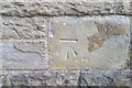
Ordnance Survey Cut Mark
This OS cut mark can be found on the SW face of St Matthais' Church. It marks a point 172.035m above mean sea level.
Image: © Adrian Dust
Taken: 14 Apr 2018
0.03 miles
6
St Matthias Church
Parish Church of Treharris.
Image: © Alan Hughes
Taken: 31 Jul 2020
0.04 miles
7
Treharris Health Centre
Set back from, and above, Cardiff Road, located between St Matthias church http://www.geograph.org.uk/photo/2311630 and Treharris Bus Station. http://www.geograph.org.uk/photo/2311548
Image: © Jaggery
Taken: 17 Mar 2011
0.04 miles
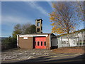
9
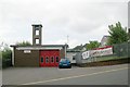
Treharris Fire Station
Treharris Fire Station, Thomas Street, Treharris
Image: © Kevin Hale
Taken: 4 Jun 2007
0.04 miles