1
Park Lane Treharris
On the north side of Commercial Terrace, near the Edwardsville boundary.
Image: © Jaggery
Taken: 27 Mar 2014
0.01 miles
2
Junctions at the edge of Treharris
Commercial Terrace heads north away from the A4054 Cardiff Road.
The Park Lane junction is in the background on the left.
A Croeso i Treharris (Welsh for Welcome to Treharris) information board http://www.geograph.org.uk/photo/3915557 is on the grass on the right.
Image: © Jaggery
Taken: 30 Jan 2016
0.02 miles
3
No motor vehicles allowed in Park Lane, Treharris
Looking west from Commercial Terrace.
Image: © Jaggery
Taken: 27 Mar 2014
0.03 miles
4
Hairpin bend in Treharris
Commercial Terrace from the left joins the A4054 Cardiff Road.
Image: © Jaggery
Taken: 27 Mar 2014
0.04 miles
5
Croeso i Treharris
Located at the edge of a hairpin bend. http://www.geograph.org.uk/photo/3915092
The metal plate showing Croeso i Treharris (Welsh for Welcome to Treharris) is above a Treharris information board in English. Among the many facts on display, I learnt that the pre-industrial name for this area was Twyn y Garreg (rock or stone hillock). The town was formed in the 1870s around the Deep Navigation Colliery, owned by F.W.Harris. The colliery's original name was Harris's Navigation Pits. Treharris is literally Harris's Town.
Image: © Jaggery
Taken: 27 Mar 2014
0.04 miles
6
Stone walls and wooden fences, Treharris
Looking west up Park Lane.
Image: © Jaggery
Taken: 27 Mar 2014
0.05 miles
7
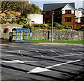
White arrows and blue bus shelter, Treharris
Viewed across the A4054 Cardiff Road.
Image: © Jaggery
Taken: 30 Jan 2016
0.07 miles
8
Masonry remains of a railway bridge in Treharris
Viewed across the A4054 Cardiff Road near Susannah Place. Old maps show that this was part of the railway route between Quakers Yard High Level station and Treharris station. The route closed in 1964 and both stations have gone. The present-day Quakers Yard station http://www.geograph.org.uk/photo/3904668 is a smaller version of the original Quakers Yard Low Level station.
Image: © Jaggery
Taken: 27 Mar 2014
0.08 miles
9
Blackbrook, Treharris
Blackbrook is part of the B4254 Cardiff Road. The postbox is from the reign of King George V. http://www.geograph.org.uk/photo/4044607
Image: © Jaggery
Taken: 27 Mar 2014
0.08 miles
10
King George V postbox, Blackbrook, Treharris
Located here. http://www.geograph.org.uk/photo/4044600
Image: © Jaggery
Taken: 27 Mar 2014
0.08 miles


