IMAGES TAKEN NEAR TO
Edwards Terrace, TREHARRIS, CF46 5DA
Introduction
This page details the photographs taken nearby to Edwards Terrace, CF46 5DA by members of the Geograph project.
The Geograph project started in 2005 with the aim of publishing, organising and preserving representative images for every square kilometre of Great Britain, Ireland and the Isle of Man.

There are currently over 7.5m images from over14,400 individuals and you can help contribute to the project by visiting https://www.geograph.org.uk
Image Map (Loading...)


Getting Data...Please wait
Leaflet Map data © OpenStreetMap
Images are licensed for reuse under creativecommons.org/licenses/by-sa/2.0
Notes
- Clicking on the map will re-center to the selected point.
- The higher the marker number, the further away the image location is from the centre of the postcode.
Image Listing (60 Images Found)
Images are licensed for reuse under creativecommons.org/licenses/by-sa/2.0
Image
Details
Distance
1
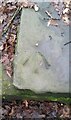
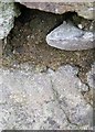
Ordnance Survey Rivet
This OS rivet can be found on the stone stile remains. It marks a point 148.297m above mean sea level.
Image: © Adrian Dust
Taken: 1 Feb 2021
0.11 miles
2
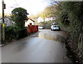
Quakers Yard side road
On the east side of Dan-y-twyn in Quakers Yard, past the edge of Salon 2000. http://www.geograph.org.uk/photo/4809246
Image: © Jaggery
Taken: 30 Jan 2016
0.12 miles
3
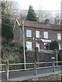
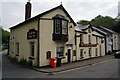
Quakers? Yard: post office
This branch will close down at the end of February 2008.
Image: © Chris Downer
Taken: 18 Feb 2008
0.12 miles
4
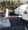
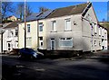
Row of houses, Dan-y-twyn, Quakers Yard
Houses set above road level, accessed up steps.
Image: © Jaggery
Taken: 30 Jan 2016
0.12 miles
5

Salon 2000, Quakers Yard
Hairdressers at 9 Dan-y-twyn, Quakers Yard
Image: © Jaggery
Taken: 30 Jan 2016
0.13 miles
7
Ordnance Survey Rivet
This OS rivet (arrow lost to cement covering) can be found on the stone SE side of Wingfield Terrace. It marks a point 140.790m above mean sea level.
Image: © Adrian Dust
Taken: 7 Oct 2018
0.13 miles
8
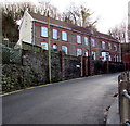
Bend in Cardiff Road towards the centre of Quakers Yard
The Glantaff Inn http://www.geograph.org.uk/photo/4813644 and the A4054 are behind the camera.
Image: © Jaggery
Taken: 30 Jan 2016
0.13 miles
9
Solar panels on a Quakers Yard house roof
The Dan-y-twyn house is next door to Tin Sang Chinese takeaway. http://www.geograph.org.uk/photo/4809288
Image: © Jaggery
Taken: 30 Jan 2016
0.14 miles
10
Quakers Yard information board
The board states that the community of Quakers Yard, near Treharris, takes its name from the Quaker graveyard which opened in 1667. The area had previously been known as Rhyd y Grug (Ford of the Rustling Waters). The ford was a crossing of the River Taff near the confluence http://www.geograph.org.uk/photo/4813660 of the smaller Bargod Taf river.
Image: © Jaggery
Taken: 30 Jan 2016
0.15 miles