IMAGES TAKEN NEAR TO
Navigation Park, MOUNTAIN ASH, CF45 4SN
Introduction
This page details the photographs taken nearby to Navigation Park, CF45 4SN by members of the Geograph project.
The Geograph project started in 2005 with the aim of publishing, organising and preserving representative images for every square kilometre of Great Britain, Ireland and the Isle of Man.

There are currently over 7.5m images from over14,400 individuals and you can help contribute to the project by visiting https://www.geograph.org.uk
Image Map
Images are licensed for reuse under creativecommons.org/licenses/by-sa/2.0
Notes
- Clicking on the map will re-center to the selected point.
- The higher the marker number, the further away the image location is from the centre of the postcode.
Image Listing (129 Images Found)
Images are licensed for reuse under creativecommons.org/licenses/by-sa/2.0
Image
Details
Distance
1
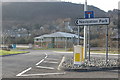
Entrance to Navigation Park, Abercynon
Image: © Roger Cornfoot
Taken: 14 Mar 2009
0.01 miles
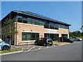
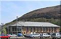
2
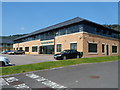
Ynysmeurig House, Abercynon
One of several recently-built offices in Navigation Park.
Image: © Jaggery
Taken: 10 Aug 2012
0.01 miles
3
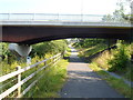
River bridge crosses over a cycle route, Abercynon
A combined cycle route and footpath along the bank of the River Taff pass under a bridge
built as part of the Abercynon Park and Ride project. http://www.geograph.org.uk/photo/3076450
Image: © Jaggery
Taken: 10 Aug 2012
0.03 miles
4
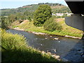
Across the Taff, Abercynon
Looking across the River Taff from a footpath and cycleway, viewed from under this http://www.geograph.org.uk/photo/3076892 bridge.
Image: © Jaggery
Taken: 10 Aug 2012
0.03 miles
5
Cynon Taf Community Housing Group offices, Abercynon
Located in Unit 4, Navigation Park.
Image: © Jaggery
Taken: 10 Aug 2012
0.04 miles
6
Ty Cynon, Abercynon
Ty Cynon (Cynon House) is one of several recently-built offices in Navigation Park.
Image: © Jaggery
Taken: 10 Aug 2012
0.05 miles
7
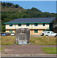
Abercynon Colliery miners' memorial, Navigation Park
Located in front of Ty Cynon http://www.geograph.org.uk/photo/3076583 in Navigation Park Abercynon.
The memorial was erected in honour of the men who worked - and died - in Abercynon Colliery which occupied this site from 1889 to 1988. The memorial was the work of artist John Allinson of Penderyn.
It was dedicated on March 31st 1995 by Ken Harrison, a former banksman at the colliery.
Image: © Jaggery
Taken: 10 Aug 2012
0.05 miles
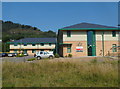
8
Innovation Centre, Mountain Ash
Partial Offices of Rhondda-Cynon Taff Council
Image: © Rick Crowley
Taken: 22 Apr 2010
0.05 miles
9
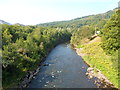
River Taff downstream from a bridge near Abercynon railway station
The Taff flows away from this bridge. http://www.geograph.org.uk/photo/3076521
Image: © Jaggery
Taken: 10 Aug 2012
0.06 miles
10
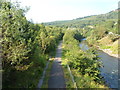
Riverside cycle route and footpath, Abercynon
Viewed from this bridge. http://www.geograph.org.uk/photo/3076521 The cycle route is along the bank of the River Taff.
Image: © Jaggery
Taken: 10 Aug 2012
0.06 miles