IMAGES TAKEN NEAR TO
Abercynon, MOUNTAIN ASH, CF45 4RT
Introduction
This page details the photographs taken nearby to CF45 4RT by members of the Geograph project.
The Geograph project started in 2005 with the aim of publishing, organising and preserving representative images for every square kilometre of Great Britain, Ireland and the Isle of Man.

There are currently over 7.5m images from over14,400 individuals and you can help contribute to the project by visiting https://www.geograph.org.uk
Image Map
Images are licensed for reuse under creativecommons.org/licenses/by-sa/2.0
Notes
- Clicking on the map will re-center to the selected point.
- The higher the marker number, the further away the image location is from the centre of the postcode.
Image Listing (145 Images Found)
Images are licensed for reuse under creativecommons.org/licenses/by-sa/2.0
Image
Details
Distance
1
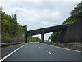
B4275 bridge over A470
The bridge gives access to the quarries on Craig-Evan-Leyshan Common
Image: © David Smith
Taken: 7 Jul 2011
0.02 miles
2
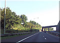
Bridge carrying southbound B4275 over A470
Image: © John Firth
Taken: 7 Sep 2012
0.03 miles
3
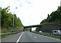
Bridge for B4275 over A470
Part of a complex junction, squeezed between the hillside and village, this carries the southbound B4275
Image: © David Smith
Taken: 21 Sep 2022
0.03 miles
4
Navigation House, Abercynon
Navigation House predates the village which surrounds it. It was originally situated by the Glamorganshire Canal at the terminus of a tramway where, in 1804 Richard Trevithick demonstrated the world's first steam locomotive running on rails and hauling a load of 10 tons.
Image: © Robin Williams
Taken: 23 Oct 2005
0.06 miles
5
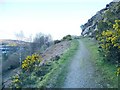
Dismantled railway climbs Craig Evan-Leyshon
The path of a dismantled railway leaves the Taff Trail and ascends to avoid the road below.
Image: © Nigel Davies
Taken: 5 Apr 2008
0.11 miles
6
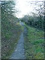
Derelict road forming part of Taff Trail
The moss and grass have almost completely reclaimed the tarmac. Only a well travelled strip and the occasional manhole cover make this feel like part of a road at all. The map shows that this is now part of Cycle Route 8 and the Taff Trail.
By consulting older maps, contributor Colin Bell confirms it was the original path of the 470 (now renumbered A4054) which runs around the hill in a slightly wider and lower arc out of shot to the right. The new A470 is the dual carriageway, yet another road running parallel.
Image: © Nigel Davies
Taken: 5 Apr 2008
0.11 miles
7
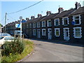
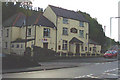
Martin's Terrace, Abercynon
Viewed from a footpath and cycle route along the bank of the River Taff.
Blue arms on a signpost show various routes and distances.
Image: © Jaggery
Taken: 10 Aug 2012
0.11 miles
9
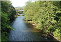
River Taff between two bridges, Abercynon
Looking downstream from this bridge http://www.geograph.org.uk/photo/3076932 looking towards a newer bridge. http://www.geograph.org.uk/photo/3076521
Image: © Jaggery
Taken: 10 Aug 2012
0.13 miles
10
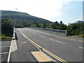
River Taff bridge near Abercynon railway station
Viewed from the station side. The bridge and access road were built as part of the Abercynon Park and Ride project. http://www.geograph.org.uk/photo/3076450
Image: © Jaggery
Taken: 10 Aug 2012
0.14 miles