IMAGES TAKEN NEAR TO
Abercynon, MOUNTAIN ASH, CF45 4NJ
Introduction
This page details the photographs taken nearby to CF45 4NJ by members of the Geograph project.
The Geograph project started in 2005 with the aim of publishing, organising and preserving representative images for every square kilometre of Great Britain, Ireland and the Isle of Man.

There are currently over 7.5m images from over14,400 individuals and you can help contribute to the project by visiting https://www.geograph.org.uk
Image Map
Images are licensed for reuse under creativecommons.org/licenses/by-sa/2.0
Notes
- Clicking on the map will re-center to the selected point.
- The higher the marker number, the further away the image location is from the centre of the postcode.
Image Listing (9 Images Found)
Images are licensed for reuse under creativecommons.org/licenses/by-sa/2.0
Image
Details
Distance
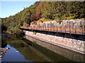
1
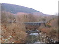
Pipe bridge by Abercynon
This bridge was formerly the railway line from Pontypridd to Ystrad Mynach which involved a steep climb (it can be seen in the photo that the left of the main span is lower than the right).
Image: © nantcoly
Taken: 6 Feb 2006
0.15 miles
3
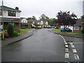
Grove Field Estate
This looks like a newish estate.
Image: © Nick Mutton 01329 000000
Taken: 23 Sep 2007
0.20 miles
4
Bridge over the River Taff
Disused railway bridge over the Taff below Abercynon.
Image: © Alan Hughes
Taken: 27 Mar 2019
0.20 miles
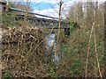
5
Disused cantilevered mine railway/conveyor
This structure hangs over the river Taff and may have been a railway or conveyor belt
Image: © nantcoly
Taken: 3 Aug 2006
0.21 miles
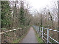
6
View of Mynydd Eglwysilan from Lon Las Cymru
Taken from a handily placed bench.
Image: © John Light
Taken: 4 Jan 2013
0.22 miles
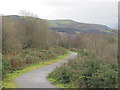
7
Lon Las Cymru between Abercynon and Cilfynydd
Apparently the Taff Trail route follows the A4054 between Cilfynydd and Abercynon, but that seems silly as this relatively new stretch of cycle path is now available .
Image: © John Light
Taken: 4 Jan 2013
0.22 miles
8
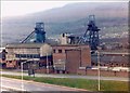
Abercynon Colliery in the 1980's
Photograph showing the downcast and upcast shaft headgears. Colliery closed in 1988. In foreground shows pit head baths.
Image: © jeff lewis
Taken: Unknown
0.22 miles
