IMAGES TAKEN NEAR TO
Woodfield Terrace, MOUNTAIN ASH, CF45 3UU
Introduction
This page details the photographs taken nearby to Woodfield Terrace, CF45 3UU by members of the Geograph project.
The Geograph project started in 2005 with the aim of publishing, organising and preserving representative images for every square kilometre of Great Britain, Ireland and the Isle of Man.

There are currently over 7.5m images from over14,400 individuals and you can help contribute to the project by visiting https://www.geograph.org.uk
Image Map (Loading...)


Getting Data...Please wait
Leaflet Map data © OpenStreetMap
Images are licensed for reuse under creativecommons.org/licenses/by-sa/2.0
Notes
- Clicking on the map will re-center to the selected point.
- The higher the marker number, the further away the image location is from the centre of the postcode.
Image Listing (69 Images Found)
Images are licensed for reuse under creativecommons.org/licenses/by-sa/2.0
Image
Details
Distance
1
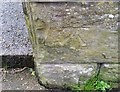
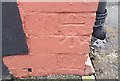
Ordnance Survey Cut Mark
This OS cut mark can be found on the wall of No79 Woodfield Terrace. It marks a point 126.309m above mean sea level.
Image: © Adrian Dust
Taken: 15 Apr 2018
0.03 miles
2
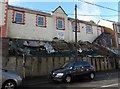
House construction in Penrhiwceiber
Viewed across Penrhiwceiber Road in early February 2014. The Google Earth Street View taken in November 2008 shows an area of grass here. I wondered what, if anything, had previously occupied the site. The clues are contradictory. The postbox suggests perhaps a post office, but the neighbouring houses are numbered 107 and 109 (108 is on the even-numbered opposite side of the road) which suggests a building without a number, maybe a chapel or church.
Image: © Jaggery
Taken: 4 Feb 2014
0.03 miles
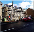
3
Penrhiwceiber Constitutional Club, Penrhiwceiber
129-133 Penrhiwceiber Road.
Image: © Jaggery
Taken: 4 Feb 2014
0.05 miles
4
Harcourt Terrace, Penrhiwceiber
Viewed from the corner of George Terrace. http://www.geograph.org.uk/photo/3838569
Image: © Jaggery
Taken: 4 Feb 2014
0.06 miles
5
Railway towards Mountain Ash from Penrhiwceiber
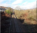
Viewed from this http://www.geograph.org.uk/photo/3838738 footbridge looking along a single-track section of the Aberdare Branch of the Merthyr Line, between Penrhiwceiber station 300 metres behind the camera and Mountain Ash station about 1300 metres ahead. Houses in Harcourt Terrace http://www.geograph.org.uk/photo/3838575 are on the left.
Image: © Jaggery
Taken: 4 Feb 2014
0.07 miles
6
Ordnance Survey Cut Mark
This OS cut mark can be found on No78 Tanycoed Street. It marks a point 141.110m above mean sea level.
Image: © Adrian Dust
Taken: 15 Apr 2018
0.08 miles
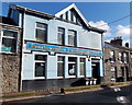
7
A.N.A Boxing Club, Penrhiwceiber
Amateur boxing club at 160 Penrhiwceiber Road.
Image: © Jaggery
Taken: 4 Feb 2014
0.08 miles
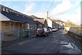
8
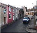
Up George Terrace in Penrhiwceiber
Viewed from Harcourt Terrace looking up George Terrace towards Penrhiwceiber Road.
Walking in parts of Penrhiwceiber needs - or develops - strong legs.
http://www.geograph.org.uk/photo/3838577 to a view down George Terrace.
Image: © Jaggery
Taken: 4 Feb 2014
0.09 miles
9
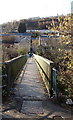
Footbridges from business park to the village, Penrhiwceiber
Viewed from the Cwm Cynon Business and Industrial Park side looking towards the corner of Harcourt Terrace and George Terrace. There are two joined footbridges here. The one nearer the camera crosses a river, the Afon Cynon. The other one crosses the Aberdare Branch of the Merthyr Line railway.
http://www.geograph.org.uk/photo/3838738 to a side view of both bridges.
Image: © Jaggery
Taken: 4 Feb 2014
0.09 miles
10
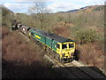
Coal train near Penrhiwceiber
Friday, 24th February 2017 marked the last day of coal-train workings from Tower Colliery to Aberthaw Power Station. The penultimate loaded train was headed by Freightliner Class 66 locomotive No. 66511, and is seen descending the valley between Mountain Ash and Penrhiwceiber stations
Image: © Gareth James
Taken: 24 Feb 2017
0.10 miles