IMAGES TAKEN NEAR TO
Abercynon Road, MOUNTAIN ASH, CF45 3NZ
Introduction
This page details the photographs taken nearby to Abercynon Road, CF45 3NZ by members of the Geograph project.
The Geograph project started in 2005 with the aim of publishing, organising and preserving representative images for every square kilometre of Great Britain, Ireland and the Isle of Man.

There are currently over 7.5m images from over14,400 individuals and you can help contribute to the project by visiting https://www.geograph.org.uk
Image Map
Images are licensed for reuse under creativecommons.org/licenses/by-sa/2.0
Notes
- Clicking on the map will re-center to the selected point.
- The higher the marker number, the further away the image location is from the centre of the postcode.
Image Listing (62 Images Found)
Images are licensed for reuse under creativecommons.org/licenses/by-sa/2.0
Image
Details
Distance
1
Welcome to Penrhiwceiber banner
Located alongside the B4275 Abercynon Road at the SE edge of the village. It is facing the wrong way, towards drivers and walkers leaving Penrhiwceiber on the road to Abercynon. The explanation is a mixture of geography and bilingualism. The bank on the opposite side of the road leaves no room for a sign there. On the back on this sign is one in Welsh, http://www.geograph.org.uk/photo/3891455 facing those entering the village.
The depiction on the banner is titled Eat a Rainbow. The rainbow in question is a variety of variously coloured fruit and vegetables. The banner was designed by the Learning Observation Class at Penrhiwceiber Primary School.
Image: © Jaggery
Taken: 30 Jan 2014
0.04 miles
2
Croeso i Benrhiwceiber banner, Penrhiwceiber
The welcome banner in Welsh is alongside the B4275 at the SE entrance to the village from Abercynon. Benrhiwceiber is a mutated form of Penrhiwceiber. The banner is titled Cysgu yn Dda, Welsh for Sleep Well. The banner was designed by pupils at Penrhiwceiber Primary School.
An English language Welcome banner http://www.geograph.org.uk/photo/3891438 is on the other side.
Image: © Jaggery
Taken: 30 Jan 2014
0.04 miles
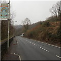
3
From Vaughan Terrace to Abercynon Road, Penrhiwceiber
The B4275 Vaughan Terrace http://www.geograph.org.uk/photo/3891234 behind the camera becomes the B4275 Abercynon Road ahead.
Image: © Jaggery
Taken: 30 Jan 2014
0.04 miles
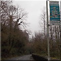
4

Give way 50 yards ahead, Glamorgan Street, Perthcelyn
The sign on the left draws attention to traffic calming http://www.geograph.org.uk/photo/3950322 ahead.
Image: © Jaggery
Taken: 30 Jan 2014
0.05 miles
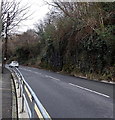
5
Traffic calming in Perthcelyn
This narrowing of the Glamorgan Street roadway is intended to slow down traffic through
a residential area. Traffic ascending the hill has priority over descending traffic.
Image: © Jaggery
Taken: 30 Jan 2014
0.06 miles
6
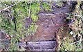
Ordnance Survey Cut Mark
This OS cut mark can be found on the wall west side of Abercynon Road. It marks a point 116.806m above mean sea level.
Image: © Adrian Dust
Taken: 15 Apr 2018
0.06 miles
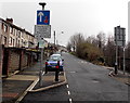
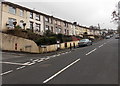
7
Road junction
Junction of Monmouth Street and Glamorgan Street at Perthcelyn.
Image: © Alan Hughes
Taken: 27 Mar 2019
0.06 miles
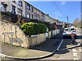
8
Long row of houses, Glamorgan Street, Perthcelyn
A long row of houses extends for 150 metres from the Monmouth Street junction.
The postbox http://www.geograph.org.uk/photo/3950271 in the wall has a King George VI monogram.
Image: © Jaggery
Taken: 30 Jan 2014
0.07 miles
9
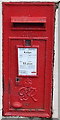
King George VI postbox in Perthcelyn
Located here http://www.geograph.org.uk/photo/3950268 on the Monmouth Street side of the Glamorgan Street junction.
The monogram dates the box to the reign of King George VI (December 1936- February 1952).
Image: © Jaggery
Taken: 30 Jan 2014
0.07 miles
10

Barrier across the Glamorgan Street end of a footpath in Perthcelyn
The path leads to Penybryn Road.
Image: © Jaggery
Taken: 30 Jan 2014
0.07 miles