1
King George VI postbox in Perthcelyn
Located here http://www.geograph.org.uk/photo/3950268 on the Monmouth Street side of the Glamorgan Street junction.
The monogram dates the box to the reign of King George VI (December 1936- February 1952).
Image: © Jaggery
Taken: 30 Jan 2014
0.03 miles
2
Glamorgan Street
Road leading from Perthcelyn to the junction with the Abercynon Road.
Image: © Alan Hughes
Taken: 27 Mar 2019
0.03 miles
3
Road junction
Junction of Monmouth Street and Glamorgan Street at Perthcelyn.
Image: © Alan Hughes
Taken: 27 Mar 2019
0.03 miles
4
Hairpin bend in Perthcelyn
The road from Monmouth Street on the left to Glamorgan Street on the right.
Image: © Jaggery
Taken: 30 Jan 2014
0.04 miles
5
View from Dillington Terrace
View through a clump of trees down to the Abercynon Road.
Image: © Alan Hughes
Taken: 27 Mar 2019
0.04 miles
6
Down Monmouth Street, Perthcelyn
Monmouth Street is parallel with Glamorgan Street. Access to both ends of the street is from Glamorgan Street. The houses on the right are opposite the backs of Glamorgan Street houses on the left.
Image: © Jaggery
Taken: 30 Jan 2014
0.04 miles
7
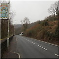
Welcome to Penrhiwceiber banner
Located alongside the B4275 Abercynon Road at the SE edge of the village. It is facing the wrong way, towards drivers and walkers leaving Penrhiwceiber on the road to Abercynon. The explanation is a mixture of geography and bilingualism. The bank on the opposite side of the road leaves no room for a sign there. On the back on this sign is one in Welsh, http://www.geograph.org.uk/photo/3891455 facing those entering the village.
The depiction on the banner is titled Eat a Rainbow. The rainbow in question is a variety of variously coloured fruit and vegetables. The banner was designed by the Learning Observation Class at Penrhiwceiber Primary School.
Image: © Jaggery
Taken: 30 Jan 2014
0.04 miles
8
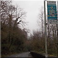
Croeso i Benrhiwceiber banner, Penrhiwceiber
The welcome banner in Welsh is alongside the B4275 at the SE entrance to the village from Abercynon. Benrhiwceiber is a mutated form of Penrhiwceiber. The banner is titled Cysgu yn Dda, Welsh for Sleep Well. The banner was designed by pupils at Penrhiwceiber Primary School.
An English language Welcome banner http://www.geograph.org.uk/photo/3891438 is on the other side.
Image: © Jaggery
Taken: 30 Jan 2014
0.04 miles
9
Give way 50 yards ahead, Glamorgan Street, Perthcelyn
The sign on the left draws attention to traffic calming http://www.geograph.org.uk/photo/3950322 ahead.
Image: © Jaggery
Taken: 30 Jan 2014
0.05 miles
10
Signposts at Perthcelyn
Perthcelyn is a village and district of the community between Penrhiwceiber and Mountain Ash within the Cynon Valley in the county borough of Rhondda Cynon Taf.
Image: © Alan Hughes
Taken: 27 Mar 2019
0.05 miles


