IMAGES TAKEN NEAR TO
Richmond Drive, ABERDARE, CF44 9UA
Introduction
This page details the photographs taken nearby to Richmond Drive, CF44 9UA by members of the Geograph project.
The Geograph project started in 2005 with the aim of publishing, organising and preserving representative images for every square kilometre of Great Britain, Ireland and the Isle of Man.

There are currently over 7.5m images from over14,400 individuals and you can help contribute to the project by visiting https://www.geograph.org.uk
Image Map
Images are licensed for reuse under creativecommons.org/licenses/by-sa/2.0
Notes
- Clicking on the map will re-center to the selected point.
- The higher the marker number, the further away the image location is from the centre of the postcode.
Image Listing (11 Images Found)
Images are licensed for reuse under creativecommons.org/licenses/by-sa/2.0
Image
Details
Distance
1
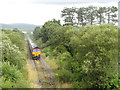
Railtour at Hirwaun
UK Railtours brought a pair of class 66 locomotives, Nos. 66011 and 66116, in top-and-tail formation, to South Wales on their Valley Legend railtour. The tour visited the Ebbw Vale and Tower Colliery branches, and is seen at Hirwaun, soon after departing Tower; with the closure of this opencast site, this may well be the last passenger train to visit the Aberdare-Tower branch.
Image: © Gareth James
Taken: 30 Jul 2017
0.11 miles
3
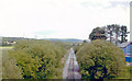
East on mineral line at Hirwaun
View eastward from the A4059 Hirwaun - Brecon road, towards Aberdare, Quaker's Yard and Pontypool Road: ex-GWR Neath - Pontypool Road line. Hirwaun station had been a little to the east: it lost its through passenger services and those on the branch to Merthyr from 15/6/64 and most freight from 1/3/65, but freight continued Hirwaun Pond - Glyn Neath until 6/11/67 and eastward traffic to Aberdare remains from Tower Colliery and the Rhigos Mountain opencast coal workings.
Image: © Ben Brooksbank
Taken: 22 Jun 2004
0.21 miles
5
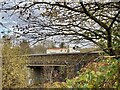
Railway bridge on the Hirwaun to Penderyn road
New road bridge over the disused railway cutting. See also Image
Image: © Alan Hughes
Taken: 9 Nov 2020
0.22 miles
6
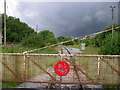
Disused railway line at Hirwaun
Vegetation is encroaching on the tracks running from this level crossing at the northern edge of Hirwaun. This spot is right on the boundary of Brecon Beacons National Park which lies to the right (north).
Image: © Alan Bowring
Taken: 3 Jul 2007
0.22 miles
7
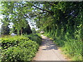
Llwybr i Benderyn / Path to Penderyn
Cyn dramffordd a agorwyd yn 1780au i gludo cerrig calch a silica i lawr o'r cwarau ar lethrau Moel Penderyn at Waith Haearn Hiwaun. Fe ddaeth yn rheilffordd maes o law ac heddiw y mae'n llwybr dymunol iawn.
Opened during the 1780s the former tramway (and later railway) transported limestone and silica from the quarries at Moel Penderyn to Hirwaun Iron Works. Today, it's a very pleasant path.
Image: © Alan Richards
Taken: 7 Jun 2023
0.23 miles
8
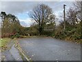
The old road from Hirwaun to Penderyn
Beyond the hedge is a steep drop into a disused railway cutting. The old bridge has been removed.
Image: © Alan Hughes
Taken: 9 Nov 2020
0.24 miles
9
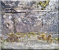
Ordnance Survey Cut Mark
This OS cut mark can be found on the SW parapet of the bridge. It marks a point 189.820m above mean sea level.
Image: © Adrian Dust
Taken: 13 Aug 2020
0.24 miles
10
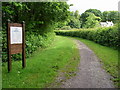
Penderyn Quarry Line Cycleway
This former railway line branched off at Hirwaun bound for the limestone quarry at penderyn a couple of miles to the north. Long disused, it has been converted into a cycling and walking trail by Brecon Beacons National Park Authority. The railway extended for short period beyond Penderyn all the way up to Ystradfellte Reservoir to serve the construction of the dam.
Image: © Alan Bowring
Taken: 3 Jul 2007
0.25 miles