IMAGES TAKEN NEAR TO
Redhill Close, ABERDARE, CF44 9NZ
Introduction
This page details the photographs taken nearby to Redhill Close, CF44 9NZ by members of the Geograph project.
The Geograph project started in 2005 with the aim of publishing, organising and preserving representative images for every square kilometre of Great Britain, Ireland and the Isle of Man.

There are currently over 7.5m images from over14,400 individuals and you can help contribute to the project by visiting https://www.geograph.org.uk
Image Map
Images are licensed for reuse under creativecommons.org/licenses/by-sa/2.0
Notes
- Clicking on the map will re-center to the selected point.
- The higher the marker number, the further away the image location is from the centre of the postcode.
Image Listing (6 Images Found)
Images are licensed for reuse under creativecommons.org/licenses/by-sa/2.0
Image
Details
Distance
1
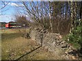
Sad sight on a roundabout
This is one of four dry stone walls built as a feature on the Hirwaun roundabout on the Heads of the Valleys Road in the early 1990s. Unfortunately, it wasn't very well built, and no maintenance was thought necessary.
Image: © CHARLES GORDON CLARK
Taken: 10 Mar 2010
0.08 miles
2
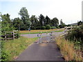
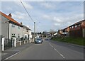
Llwybr Becio Hirwaun / Hirwaun Cycle Path
Darn fach o lwybr beicio yn cyrraedd cylchdro brysur iawn yn Hirwaun.
A short section of cycle track approaching a very busy roundabout in Hirwaun (trans. long moor).
Image: © Alan Richards
Taken: 17 Jul 2017
0.13 miles
3
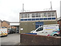
Hirwaun Telephone Exchange
Situated in Rhigos Road, this TE is of a standard design dating from the 1970s and has the code SWHJL. It provides telephone and broadband services to 3,876 residential and 120 non-residential premises in Hirwaun plus Penderyn, Penywaun and Rhigos nearby. Two Openreach vehicles can be seen parked in front of this building. The numbering range of this TE is (01685) 81xxxx, the (01685) referring to the Merthyr Tydfil of four TEs, and its postcode is CF44 9PS.
Image: © David Hillas
Taken: 23 Apr 2019
0.17 miles
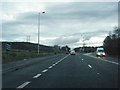
6
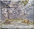
Ordnance Survey Cut Mark
This OS cut mark can be found on the SW parapet of the bridge. It marks a point 189.820m above mean sea level.
Image: © Adrian Dust
Taken: 13 Aug 2020
0.23 miles