IMAGES TAKEN NEAR TO
Hobbs Lane, ABERDARE, CF44 9BU
Introduction
This page details the photographs taken nearby to Hobbs Lane, CF44 9BU by members of the Geograph project.
The Geograph project started in 2005 with the aim of publishing, organising and preserving representative images for every square kilometre of Great Britain, Ireland and the Isle of Man.

There are currently over 7.5m images from over14,400 individuals and you can help contribute to the project by visiting https://www.geograph.org.uk
Image Map
Images are licensed for reuse under creativecommons.org/licenses/by-sa/2.0
Notes
- Clicking on the map will re-center to the selected point.
- The higher the marker number, the further away the image location is from the centre of the postcode.
Image Listing (27 Images Found)
Images are licensed for reuse under creativecommons.org/licenses/by-sa/2.0
Image
Details
Distance
1
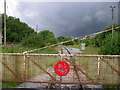
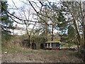
Disused railway line at Hirwaun
Vegetation is encroaching on the tracks running from this level crossing at the northern edge of Hirwaun. This spot is right on the boundary of Brecon Beacons National Park which lies to the right (north).
Image: © Alan Bowring
Taken: 3 Jul 2007
0.09 miles
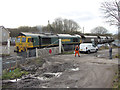
2
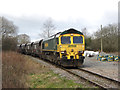
Coal train in Hirwaun
Friday, 24th February 2017 marked the last day of coal-train workings from Tower Colliery to Aberthaw Power Station. The penultimate loaded train was headed by Freightliner Class 66 locomotive No. 66511, and is seen approaching the crossing in Hirwaun.
Image: © Gareth James
Taken: 24 Feb 2017
0.11 miles
3
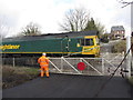
Level crossing in Hirwaun
Freightliner class 66 locomotive NO. 66511 eases over the crossing with a load of coal for Aberthaw Power Station; this would be the penultimate such trip on the last day that these operations ran.
Image: © Gareth James
Taken: 24 Feb 2017
0.12 miles
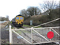
4
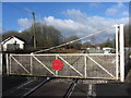
Level crossing gate in Hirwaun
Looking west from the crossing on the freight-only Aberdare-to-Tower Colliery branch.
Image: © Gareth James
Taken: 24 Feb 2017
0.12 miles
5
Industrial remains in Hirwaun
What appear to be lime kilns (plus a not-so-old trailer).
Image: © Gareth James
Taken: 24 Feb 2017
0.12 miles
6
Coal train in Hirwaun
Friday, 24th February 2017 marked the last day of coal-train workings from Tower Colliery to Aberthaw Power Station. The final loaded train was headed by Freightliner Class 66 locomotive No. 66519, and is seen here passing through Hirwaun crossing on its way, first to Aberdare, and then,in darkness, on to Aberthaw.
Image: © Gareth James
Taken: 24 Feb 2017
0.12 miles
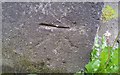
7
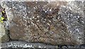
Ordnance Survey Cut Mark
This inverted OS cut mark can be found on the roadside outbuilding of Maesyrhydiau Farm. It marks a point 192.247m above mean sea level.
Image: © Adrian Dust
Taken: 12 May 2017
0.13 miles
8
Coal train at Hirwaun
Friday, 24th February 2017 marked the last day of coal-train workings from Tower Colliery to Aberthaw Power Station. The final train of empties was headed by Freightliner Class 66 locomotive No. 66519, and is seen stopped in front of Hirwaun crossing.
Image: © Gareth James
Taken: 24 Feb 2017
0.15 miles
9
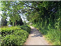
Llwybr i Benderyn / Path to Penderyn
Cyn dramffordd a agorwyd yn 1780au i gludo cerrig calch a silica i lawr o'r cwarau ar lethrau Moel Penderyn at Waith Haearn Hiwaun. Fe ddaeth yn rheilffordd maes o law ac heddiw y mae'n llwybr dymunol iawn.
Opened during the 1780s the former tramway (and later railway) transported limestone and silica from the quarries at Moel Penderyn to Hirwaun Iron Works. Today, it's a very pleasant path.
Image: © Alan Richards
Taken: 7 Jun 2023
0.16 miles
10
Ordnance Survey Cut Mark
This OS cut mark can be found on the north face of the Chapel. It marks a point 188.821m above mean sea level.
Image: © Adrian Dust
Taken: 12 May 2017
0.16 miles