IMAGES TAKEN NEAR TO
Bryn Terrace, ABERDARE, CF44 8RA
Introduction
This page details the photographs taken nearby to Bryn Terrace, CF44 8RA by members of the Geograph project.
The Geograph project started in 2005 with the aim of publishing, organising and preserving representative images for every square kilometre of Great Britain, Ireland and the Isle of Man.

There are currently over 7.5m images from over14,400 individuals and you can help contribute to the project by visiting https://www.geograph.org.uk
Image Map
Images are licensed for reuse under creativecommons.org/licenses/by-sa/2.0
Notes
- Clicking on the map will re-center to the selected point.
- The higher the marker number, the further away the image location is from the centre of the postcode.
Image Listing (106 Images Found)
Images are licensed for reuse under creativecommons.org/licenses/by-sa/2.0
Image
Details
Distance
1

Row of houses, Cwmdare Road, Cwmdare
On the descent away from Cwmdare towards Aberdare.
Image: © Jaggery
Taken: 11 Feb 2019
0.00 miles
2
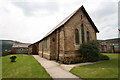
St Luke's Church, Cwmdare
St Luke's (Church in Wales) Church, Cwmdare.
Photo used with permission from Aberdare Blog Gallery http://www.aberdareblog.co.uk/
Image: © Darren W Rees
Taken: 24 Jul 2008
0.01 miles
3

Cwmdare Mission information board, Cwmdare
The red board on the right here https://www.geograph.org.uk/photo/6060223 lists the regular religious and secular activities in Cwmdare Mission in February 2019.
Image: © Jaggery
Taken: 11 Feb 2019
0.01 miles
4
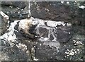
Ordnance Survey Cut Mark
This OS cut mark can be found on the wall NE side of Cwmdare Road. It marks a point 218.642m above mean sea level.
Image: © Adrian Dust
Taken: 7 Dec 2020
0.02 miles
5
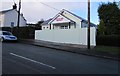
Cwmdare Mission, Cwmdare
Viewed across Cwmdare Road. In the early years of the 20th century, there were several chapels in the village, in which services were in Welsh. Cwmdare Mission was established in 1911 in the Boys School to give Cwmdare an English-speaking place of worship. The Mission has been on this site since 1921. At the end of January 2015, the building looks recently renovated.
Image: © Jaggery
Taken: 31 Jan 2015
0.02 miles
6

Cwmdare Mission
Church viewed across Cwmdare Road in February 2019. The red information
board https://www.geograph.org.uk/photo/6060231 on the church wall lists the regular religious and secular activities here.
Image: © Jaggery
Taken: 11 Feb 2019
0.02 miles
7
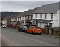
Cwmdare Road houses, Cwmdare
Looking towards the Heol Brynnau junction.
Image: © Jaggery
Taken: 5 Feb 2015
0.03 miles
8

Heol Brynnau, Cwmdare
Looking to the ESE along Heol Brynnau from Cwmdare Road.
Image: © Jaggery
Taken: 11 Feb 2019
0.04 miles
9
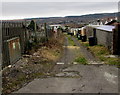
Track from King Street towards Cwmdare Road, Cwmdare
The edge of an electricity substation http://www.geograph.org.uk/photo/4341224 is on the left.
Image: © Jaggery
Taken: 5 Feb 2015
0.04 miles
10
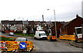
No smoking notice on a barrier, Heol Brynnau, Cwmdare
The No smoking notice on the left is displayed on a yellow barrier in early February 2015
during extensive gas mains replacement work in the area by Wales & West Utilities.
Image: © Jaggery
Taken: 5 Feb 2015
0.04 miles