IMAGES TAKEN NEAR TO
St. Johns Street, ABERDARE, CF44 8NS
Introduction
This page details the photographs taken nearby to St. Johns Street, CF44 8NS by members of the Geograph project.
The Geograph project started in 2005 with the aim of publishing, organising and preserving representative images for every square kilometre of Great Britain, Ireland and the Isle of Man.

There are currently over 7.5m images from over14,400 individuals and you can help contribute to the project by visiting https://www.geograph.org.uk
Image Map
Images are licensed for reuse under creativecommons.org/licenses/by-sa/2.0
Notes
- Clicking on the map will re-center to the selected point.
- The higher the marker number, the further away the image location is from the centre of the postcode.
Image Listing (83 Images Found)
Images are licensed for reuse under creativecommons.org/licenses/by-sa/2.0
Image
Details
Distance
2
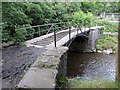
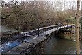
Tramroad Bridge, Aberdare
A nearby Rhondda Cynon Taf County Borough Council information board states that Tramroad Bridge (the old Iron Bridge) over the Afon Cynon, dating from 1811, is one of the world's oldest bridges of its kind.
Image: © Jaggery
Taken: 4 Feb 2014
0.05 miles
4
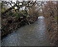
Afon Cynon flows towards Tramroad Bridge, Aberdare
Viewed from this http://www.geograph.org.uk/photo/3893973 bridge.
Image: © Jaggery
Taken: 4 Feb 2014
0.06 miles
5
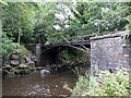
Tramroad Bridge, Aberdare
A nearby Rhondda Cynon Taf County Borough Council information board states that Tramroad Bridge (the old Iron Bridge) over the Afon Cynon, dating from 1811, is one of the world's oldest bridges of its kind.
Image: © Jaggery
Taken: 4 Feb 2014
0.06 miles
6
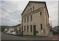
Trecynon Public Hall and Library
Trecynon Public Hall and Library on Mill Street, Trecynon.
Image: © Darren W Rees
Taken: 24 Jul 2008
0.07 miles
7
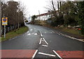
End of clearway, Meirion Street, Aberdare
The sign on the left indicates the end of a clearway (no stopping) zone.
Image: © Jaggery
Taken: 4 Feb 2014
0.07 miles
8
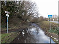
Watery route to Ken's Place, Aberdare
There was little evidence in Aberdare today (early February 2014) of the flooding that has plagued many places in southern Britain during the very wet winter of 2013-2014. This location, near the eastern end of Meirion Street, was a rare exception. One sign points along the Cynon Trail, part of National Cycle Network Route 478. Another sign points towards Ken's Place.
Image: © Jaggery
Taken: 4 Feb 2014
0.07 miles
9
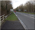
A4059 distances from Aberdare
Looking NW along the A4059 from the edge of a river bridge near Wellington Street and Meirion Street. The sign shows 3 (miles) to Hirwaun, 9 to Merthyr Tydfil and 19 to Neath.
Image: © Jaggery
Taken: 4 Feb 2014
0.07 miles
10
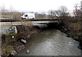
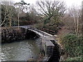
A4059 river bridge in Aberdare
The Afon Cynon flows under the A4059.
Image: © Jaggery
Taken: 4 Feb 2014
0.07 miles