IMAGES TAKEN NEAR TO
Pendarren Street, ABERDARE, CF44 7PE
Introduction
This page details the photographs taken nearby to Pendarren Street, CF44 7PE by members of the Geograph project.
The Geograph project started in 2005 with the aim of publishing, organising and preserving representative images for every square kilometre of Great Britain, Ireland and the Isle of Man.

There are currently over 7.5m images from over14,400 individuals and you can help contribute to the project by visiting https://www.geograph.org.uk
Image Map
Images are licensed for reuse under creativecommons.org/licenses/by-sa/2.0
Notes
- Clicking on the map will re-center to the selected point.
- The higher the marker number, the further away the image location is from the centre of the postcode.
Image Listing (152 Images Found)
Images are licensed for reuse under creativecommons.org/licenses/by-sa/2.0
Image
Details
Distance
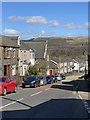
1
Pendarren Street, Aberdare
Viewed across Monk Street. The street name sign on the left, at the edge of St Joseph's Catholic Church, http://www.geograph.org.uk/photo/4337446 shows that Pendarren Street leads to Bryn Awel.
Image: © Jaggery
Taken: 5 Feb 2015
0.04 miles
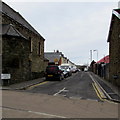
2
Car-lined Clifton Street in Aberdare
Viewed at midday on a weekday and schoolday - perhaps some of the cars
belong to members of staff at Caradog Primary School on the left.
Image: © Jaggery
Taken: 5 Feb 2015
0.05 miles
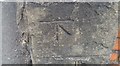
3
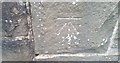
Ordnance Survey Cut Mark
This OS cut mark can be found on the NW face of the school. It marks a point 145.009m above mean sea level.
Image: © Adrian Dust
Taken: 24 Jun 2017
0.05 miles
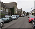
4
East side of Caradog Primary School, Aberdare
Viewed across Clifton Street. There are nearly 200 children enrolled (ages 3-11).
Image: © Jaggery
Taken: 5 Feb 2015
0.06 miles
5
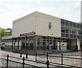
Aberdare Library
The Rhondda Cynon Taf library service has 29 libraries including 3 main libraries at Pontypridd, Treorchy and this one, located on High Street Aberdare.
Image: © Jaggery
Taken: 28 Apr 2010
0.06 miles
6
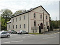
Siloa Congregational Chapel, Aberdare
Built 1844-1845 and rebuilt or modified several times since. Grade II listed status was awarded in 1998.
The chapel, located on Green Street behind the library, http://www.geograph.org.uk/photo/1830650 straddles two Ordnance Survey grid myriads. The side in view here is in the SO myriad whereas the other side http://www.geograph.org.uk/photo/1169867 is in the SN myriad.
Image: © Jaggery
Taken: 28 Apr 2010
0.06 miles
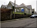
7
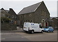
St Joseph's Catholic Church in Aberdare
Viewed across Monk Street. St Joseph's is part of the RC Parish of Mary Immaculate,
together with Our Lady of Lourdes in Mountain Ash and St Therese of Lisieux in Hirwaun.
Image: © Jaggery
Taken: 5 Feb 2015
0.07 miles
8
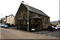
SE corner of St Joseph's Catholic Church, Aberdare
On the corner of Monk Street and Pendarren Street, St Joseph's is part of the RC Parish of Mary Immaculate, together with Our Lady of Lourdes in Mountain Ash and St Therese of Lisieux in Hirwaun.
Image: © Jaggery
Taken: 5 Feb 2015
0.07 miles
9
Monk Street
View along Monk Street, Aberdare.
Image: © Alan Hughes
Taken: 16 Mar 2020
0.07 miles
10
Ordnance Survey Cut Mark
This OS cut mark can be found on the wall of No55 Monk Street. It marks a point 143.625m above mean sea level.
Image: © Adrian Dust
Taken: 1 Jun 2017
0.08 miles