IMAGES TAKEN NEAR TO
Trevor Street, ABERDARE, CF44 7NN
Introduction
This page details the photographs taken nearby to Trevor Street, CF44 7NN by members of the Geograph project.
The Geograph project started in 2005 with the aim of publishing, organising and preserving representative images for every square kilometre of Great Britain, Ireland and the Isle of Man.

There are currently over 7.5m images from over14,400 individuals and you can help contribute to the project by visiting https://www.geograph.org.uk
Image Map
Images are licensed for reuse under creativecommons.org/licenses/by-sa/2.0
Notes
- Clicking on the map will re-center to the selected point.
- The higher the marker number, the further away the image location is from the centre of the postcode.
Image Listing (86 Images Found)
Images are licensed for reuse under creativecommons.org/licenses/by-sa/2.0
Image
Details
Distance
1
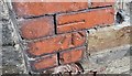
Ordnance Survey Cut Mark
This OS cut mark can be found on No20 Trevor Street. It marks a point 161.139m above mean sea level.
Image: © Adrian Dust
Taken: 1 Jun 2017
0.02 miles
3
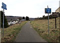
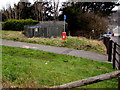
Footpath and cycleway on a former railway route from Aberdare to Cwmaman
The blue sign show 1¾ (miles) to Cwmaman. The sign pointing the other way show ¼ to the Dare Valley Country Park. The brown notice on the right shows DARE-AMAN RAILWAY PATH - NO CARS OR MOTORCYCLES.
Image: © Jaggery
Taken: 5 Feb 2015
0.02 miles
4
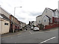
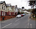
Trevor Street, Aberdare
Viewed across Monk Street.
Image: © Jaggery
Taken: 5 Feb 2015
0.03 miles
5
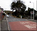
A4233 SW of Highland Place, Aberdare
Part of a long, steep ascent away from the centre of Aberdare.
Image: © Jaggery
Taken: 5 Feb 2015
0.05 miles
6
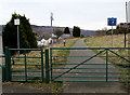
Gates at the entrance to a footpath and cycleway from Aberdare to Cwmaman
Walkers and cyclists use the small gate to access the way ahead. http://www.geograph.org.uk/photo/4340771
The wider gate is closed, secured by a metal chain and padlock.
Image: © Jaggery
Taken: 5 Feb 2015
0.05 miles
7
Right turn for the Dare Valley
Viewed across the A4233 Monk Street. A white arrow on a brown sign points
right along Highland Place towards the Dare Valley (Cwmdâr in Welsh).
Image: © Jaggery
Taken: 5 Feb 2015
0.05 miles
8
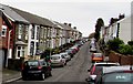
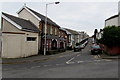
Trevor Street, Aberdare
Trevor Street is a dead-end street, extending for 170 metres SE of Monk Street.
Image: © Jaggery
Taken: 5 Feb 2015
0.06 miles
9
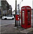
Old phonebox and new postbox in Aberdare
Alongside a bus stop on the corner of Ynysllwyd Street and Monk Street.
Image: © Jaggery
Taken: 5 Feb 2015
0.06 miles
10
Graig Isaf Aberdare electricity substation
The Western Power Distribution electricity substation is on the west side of the A4233, near Bwllfa Graig water treatment works. http://www.geograph.org.uk/photo/4340799
Image: © Jaggery
Taken: 5 Feb 2015
0.06 miles