IMAGES TAKEN NEAR TO
Boot Lane, ABERDARE, CF44 7DN
Introduction
This page details the photographs taken nearby to Boot Lane, CF44 7DN by members of the Geograph project.
The Geograph project started in 2005 with the aim of publishing, organising and preserving representative images for every square kilometre of Great Britain, Ireland and the Isle of Man.

There are currently over 7.5m images from over14,400 individuals and you can help contribute to the project by visiting https://www.geograph.org.uk
Image Map
Images are licensed for reuse under creativecommons.org/licenses/by-sa/2.0
Notes
- Clicking on the map will re-center to the selected point.
- The higher the marker number, the further away the image location is from the centre of the postcode.
Image Listing (214 Images Found)
Images are licensed for reuse under creativecommons.org/licenses/by-sa/2.0
Image
Details
Distance
1
Mile Post
Outside of Library on High Street.
Image: © Adrian Dust
Taken: 16 Jun 2017
0.02 miles
2
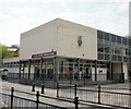
Aberdare Library
The Rhondda Cynon Taf library service has 29 libraries including 3 main libraries at Pontypridd, Treorchy and this one, located on High Street Aberdare.
Image: © Jaggery
Taken: 28 Apr 2010
0.04 miles
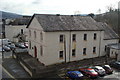
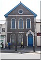
3
Siloa Congregational Chapel, Aberdare
Built 1844-1845 and rebuilt or modified several times since. Grade II listed status was awarded in 1998.
The chapel, located on Green Street behind the library, http://www.geograph.org.uk/photo/1830650 straddles two Ordnance Survey grid myriads. The side in view here is in the SO myriad whereas the other side http://www.geograph.org.uk/photo/1169867 is in the SN myriad.
Image: © Jaggery
Taken: 28 Apr 2010
0.04 miles
4
Siloa Congregational Chapel
Taken from the top floor of nearby offices.
Image: © Ruth Sharville
Taken: 19 Feb 2009
0.04 miles
5
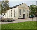
Green Street English Wesleyan Methodist Chapel, Aberdare
Built in 1859 in the Classical style. Grade II listed status was awarded in 1997.
Image: © Jaggery
Taken: 28 Apr 2010
0.05 miles
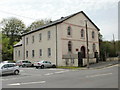
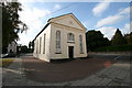
6
Trinity Chapel, Aberdare
Grade II listed Welsh Presbyterian chapel on the corner of Canon Street and Weatheral Street.
Built in 1867, renovated in 1894 and extended in 1909.
Image: © Jaggery
Taken: 28 Apr 2010
0.05 miles
7

Ordnance Survey Cut Mark
This OS cut mark can be found on the Old Town Hall building. It marks a point 129.092m above mean sea level.
Image: © Adrian Dust
Taken: 1 Jun 2017
0.05 miles
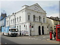
8
Provincial Grand Lodge of South Wales - Masonic Hall - Canon Street
Image: © Betty Longbottom
Taken: 27 Jun 2019
0.05 miles
9
Green Street Methodist Church, Aberdare
Green Street Methodist Church, Aberdare.
Image: © Darren W Rees
Taken: 30 Sep 2007
0.05 miles
10
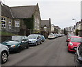
Car-lined Clifton Street in Aberdare
Viewed at midday on a weekday and schoolday - perhaps some of the cars
belong to members of staff at Caradog Primary School on the left.
Image: © Jaggery
Taken: 5 Feb 2015
0.06 miles