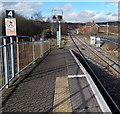
1
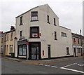
The Whitcombe Inn, Aberdare
Pub located close to the town centre, on the corner of Whitcombe Street and Pembroke Street.
Image: © Jaggery
Taken: 26 May 2010
0.05 miles
2
Ordnance Survey Cut Mark
This OS cut mark can be found on the old dairy, Gloucester Street. It marks a point 124.813m above mean sea level.
Image: © Adrian Dust
Taken: 1 Jun 2017
0.07 miles
3
Eastbound goods entering Aberdare High Level on the Vale of Neath line
The train is coming up from the direction of Hirwaun and Neath, headed by one of the 274 engines acquired in 1922 by the GWR from the Taff Vale Railway, renumbered and 'Swindonized': TVR 'A' class 0-6-2T No. 314 (built 8/1908 as No. 111, withdrawn 12/49). The combination of two Home signals on one post is somewhat unusual: the one facing protected the crossing to the Dare Valley Branch, which went off to the left. The High Level station, but not the line from Hirwaun, was closed on 13/6/64 but restored and reopened 3/10/88 as the terminus of a revived passenger service from Cardiff via Abercynon. This runs over the former Taff Vale branch by a connection with the Vale of Neath line, short of Aberdare Low Level station which had been closed on 30/10/64.
Image: © Ben Brooksbank
Taken: 14 Sep 1946
0.07 miles
4
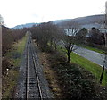
Freight-only railway towards Aberdare railway station
Viewed from here. http://www.geograph.org.uk/photo/3902732 The single-track line is from Hirwaun.
Image: © Jaggery
Taken: 4 Feb 2014
0.07 miles
5
Former Wedding Shop for sale, Aberdare
This shop on the corner of Whitcombe Street and Seymour Street used to be One Stop Wedding Shop.
Image: © Jaggery
Taken: 3 May 2014
0.07 miles
6
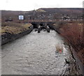
Railway bridge over the Afon Cynon, Aberdare
Viewed from Wellington Street. The river flows under the bridge carrying
a freight-only line NW of Aberdare railway station.
Image: © Jaggery
Taken: 4 Feb 2014
0.08 miles
7
Trinity Chapel, Weatherall Street Aberdare
Trinity Chapel on the corner of Weatherall Street, opposite the Aberdare Palladium.
Built in 1867.
Image: © Darren W Rees
Taken: 6 Feb 2008
0.08 miles
8
Freight track past the former Aberdare (High Level) railway station
Currently (early 2014) for freight only, the track alongside the former station http://www.geograph.org.uk/photo/3840712 continues to Hirwaun about 7km away. It was announced in March 2011 that the Welsh Assembly Government's 2011-2012 capital programme would include the reopening of this line for passenger services as part of the Cynon Valley Scheme. However, there was no sign of any such work in progress nearby.
Image: © Jaggery
Taken: 4 Feb 2014
0.08 miles
9
Afon Cynon flows past Aberdare railway station
Viewed from Abernant Road. A footpath leads up to the station.
Image: © Jaggery
Taken: 4 Feb 2014
0.08 miles
10
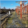
Freight line NW of Aberdare railway station
Viewed from the single platform at Aberdare railway station, the end of the line for passenger services. The freight-only line ahead extends for about 7km to Hirwaun. The long disused High Level station building is on the right.
Image: © Jaggery
Taken: 4 Feb 2014
0.09 miles


