IMAGES TAKEN NEAR TO
Glanrhyd Street, ABERDARE, CF44 6LB
Introduction
This page details the photographs taken nearby to Glanrhyd Street, CF44 6LB by members of the Geograph project.
The Geograph project started in 2005 with the aim of publishing, organising and preserving representative images for every square kilometre of Great Britain, Ireland and the Isle of Man.

There are currently over 7.5m images from over14,400 individuals and you can help contribute to the project by visiting https://www.geograph.org.uk
Image Map
Images are licensed for reuse under creativecommons.org/licenses/by-sa/2.0
Notes
- Clicking on the map will re-center to the selected point.
- The higher the marker number, the further away the image location is from the centre of the postcode.
Image Listing (17 Images Found)
Images are licensed for reuse under creativecommons.org/licenses/by-sa/2.0
Image
Details
Distance
1
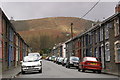
Glanrhyd Street, Cwmaman
View WNW on a damp Sunday morning
Image: © Peter Standing
Taken: 2 Apr 2006
0.03 miles
2
The end of the road
Terraced houses at the top end of Cwm Aman, the Aman valley.
The history of the growth of the village is well described in Wikipedia: https://en.m.wikipedia.org/wiki/Cwmaman
Image: © Alan Hughes
Taken: 27 Mar 2019
0.04 miles
3

West along Glanrhyd Street, Cwmaman
Looking west at the western edge of the village.
Image: © Jaggery
Taken: 22 Feb 2014
0.06 miles
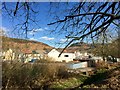
4
Fforchaman Farm buildings, Cwmaman
Viewed across Glanrhyd Street in the west of the village.
Image: © Jaggery
Taken: 22 Feb 2014
0.06 miles
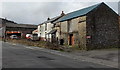
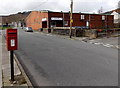
5
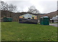
Cwmaman Community Centre
Located near the western edge of Cwmaman, on the south side of Glanrhyd Street.
The bus shelter is at a terminus, the turning point for bus services.
Image: © Jaggery
Taken: 22 Feb 2014
0.07 miles
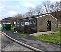
6
Greens on a green in Cwmaman
The community centre http://www.geograph.org.uk/photo/3864331 is flanked by the green body of a former railway wagon on the left and a green bus shelter on the right.
Image: © Jaggery
Taken: 22 Feb 2014
0.07 miles
7
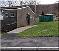
Green body of a former railway wagon in Cwmaman
Located behind the community centre. http://www.geograph.org.uk/photo/3864331
Image: © Jaggery
Taken: 22 Feb 2014
0.07 miles
8
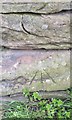
Ordnance Survey Rivet
This OS rivet can be found on a stone at the base of a barn at Fforchaman Farm. It marks a point 192.426m above mean sea level.
Image: © Adrian Dust
Taken: 22 Apr 2018
0.08 miles
9
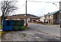
Can and bottle recycling bins in Cwmaman
Located opposite Fforchaman Farm buildings.
Image: © Jaggery
Taken: 22 Feb 2014
0.09 miles
10
Cwmaman Workmen's and Social Club
Viewed across Glanaman Road. The club is on the west bank of a stream, Nant Aman Fach.
Image: © Jaggery
Taken: 22 Feb 2014
0.09 miles