IMAGES TAKEN NEAR TO
ABERDARE, CF44 6BU
Introduction
This page details the photographs taken nearby to CF44 6BU by members of the Geograph project.
The Geograph project started in 2005 with the aim of publishing, organising and preserving representative images for every square kilometre of Great Britain, Ireland and the Isle of Man.

There are currently over 7.5m images from over14,400 individuals and you can help contribute to the project by visiting https://www.geograph.org.uk
Image Map
Images are licensed for reuse under creativecommons.org/licenses/by-sa/2.0
Notes
- Clicking on the map will re-center to the selected point.
- The higher the marker number, the further away the image location is from the centre of the postcode.
Image Listing (26 Images Found)
Images are licensed for reuse under creativecommons.org/licenses/by-sa/2.0
Image
Details
Distance
1
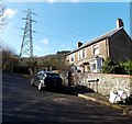
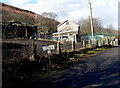
Blaencwmboi Villas, Abercwmboi
Set back from, and 150 metres south of, the B4275 Bronallt Terrace near the site of a former colliery.
Image: © Jaggery
Taken: 22 Feb 2014
0.01 miles
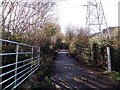
2
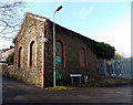
Former colliery building in Abercwmboi
Located between the B4275 Bronallt Terrace and Blaencwmboi Villas. http://www.geograph.org.uk/photo/3859680
A sign points right towards Pit Cottage past an electricity substation.
Image: © Jaggery
Taken: 22 Feb 2014
0.01 miles
3
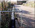
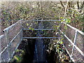
Drainage channel, Abercwmboi
Alongside an unnamed road between the B4275 Bronallt Terrace and a former colliery building. http://www.geograph.org.uk/photo/3859701
Image: © Jaggery
Taken: 22 Feb 2014
0.02 miles
4
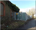
Abercwmboi Switching Site
Located at the edge of a disused colliery building. http://www.geograph.org.uk/photo/3859701 The identifier on the Western Power Distribution electricity substation is Abercwmboi Switching Site S/S No. 55-3336.
Image: © Jaggery
Taken: 22 Feb 2014
0.02 miles
5
Pit Cottage, Abercwmboi
The winding wheel on the left was part of the colliery formerly on this site.
Image: © Jaggery
Taken: 22 Feb 2014
0.04 miles
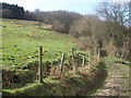
6
Lane above Blaencwmboi Villas, Abercwmboi
The lane ascends away from these http://www.geograph.org.uk/photo/3859680 houses.
Image: © Jaggery
Taken: 22 Feb 2014
0.06 miles
8
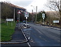
Eastern boundary of Abercwmboi
Viewed along the B4275. Abercwmboi is a village between Mountain Ash and Aberdare.
Image: © Jaggery
Taken: 22 Feb 2014
0.09 miles
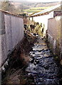
9
Drain enters a culvert under Bronallt Terrace, Abercwmboi
It looked like a stream to me, but maps show it as a drain,
one of several channels draining a hillside that used to be the site of a colliery.
Image: © Jaggery
Taken: 22 Feb 2014
0.10 miles
10
Cwm Boi flows towards Aberdare Road, Fernhill
The stream Cwm Boi is a tributary of the Afon Cynon.
Viewed from the south side of Aberdare Road.
Image: © Jaggery
Taken: 22 Feb 2014
0.13 miles