IMAGES TAKEN NEAR TO
Founders Row, ABERDARE, CF44 0TG
Introduction
This page details the photographs taken nearby to Founders Row, CF44 0TG by members of the Geograph project.
The Geograph project started in 2005 with the aim of publishing, organising and preserving representative images for every square kilometre of Great Britain, Ireland and the Isle of Man.

There are currently over 7.5m images from over14,400 individuals and you can help contribute to the project by visiting https://www.geograph.org.uk
Image Map
Images are licensed for reuse under creativecommons.org/licenses/by-sa/2.0
Notes
- Clicking on the map will re-center to the selected point.
- The higher the marker number, the further away the image location is from the centre of the postcode.
Image Listing (32 Images Found)
Images are licensed for reuse under creativecommons.org/licenses/by-sa/2.0
Image
Details
Distance
1
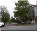
Founders Row, Llwydcoed
Looking west across the B4276. On the right, a notice on the wall showing Mucky Pups Dog Grooming points along Founders Row.
Image: © Jaggery
Taken: 3 May 2014
0.08 miles
2
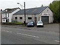
Autocare, Llwydcoed
Premises of Mike & Dean Rees, viewed across Llwydcoed Road.
Image: © Jaggery
Taken: 3 May 2014
0.08 miles
3
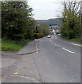
Down Llwydcoed Road towards Trecynon
The B4276 Llwydcoed Road descends south from the corner of the aptly-named side road Hill Top.
Image: © Jaggery
Taken: 3 May 2014
0.10 miles
4
Tan y Bryn Gardens, Llwydcoed
Recently-built houses on the west side of B4276 Llwydcoed Road.
Image: © Jaggery
Taken: 3 May 2014
0.10 miles
5
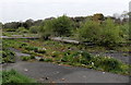
Derelict site at the edge of Trecynon
Trees and weeds grow on the base of demolished buildings located between a side road, Gelli Isaf,
and a river, Afon Cynon. In view is a section of the site which measures about 150 metres by 90 metres.
Image: © Jaggery
Taken: 3 May 2014
0.11 miles
6
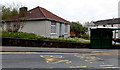
Dandelion seeds in Windy Ridge, Llwydcoed
Despite the name of the bungalow, Windy Ridge, dandelion seeds remain undispersed in the garden.
Image: © Jaggery
Taken: 3 May 2014
0.11 miles
7
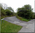
Hill Top, Llwydcoed
A side road heads away from the B4276 Llwydcoed Road.
Image: © Jaggery
Taken: 3 May 2014
0.11 miles
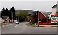
8
Maes-y-Ffion, Llwydcoed
A Bellway development of 3- and 4-bedroom detached houses on the west side of the B4276.
Image: © Jaggery
Taken: 3 May 2014
0.11 miles
9
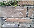
Ordnance Survey Cut Mark
This OS cut mark can be found on the wall NE side of the road. It marks a point 173.501m above mean sea level.
Image: © Adrian Dust
Taken: 7 Dec 2020
0.12 miles
10
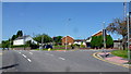
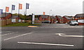
Llwydcoed Road
Junction with Bryn Moreia and Maes Yr Haf.
Image: © Jonathan Billinger
Taken: 22 Aug 2013
0.12 miles