IMAGES TAKEN NEAR TO
Maeshyfryd, ABERDARE, CF44 0DL
Introduction
This page details the photographs taken nearby to Maeshyfryd, CF44 0DL by members of the Geograph project.
The Geograph project started in 2005 with the aim of publishing, organising and preserving representative images for every square kilometre of Great Britain, Ireland and the Isle of Man.

There are currently over 7.5m images from over14,400 individuals and you can help contribute to the project by visiting https://www.geograph.org.uk
Image Map
Images are licensed for reuse under creativecommons.org/licenses/by-sa/2.0
Notes
- Clicking on the map will re-center to the selected point.
- The higher the marker number, the further away the image location is from the centre of the postcode.
Image Listing (65 Images Found)
Images are licensed for reuse under creativecommons.org/licenses/by-sa/2.0
Image
Details
Distance
1
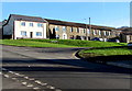
Richard's Terrace houses, Cwmbach
Houses above Tirfounder Road viewed across Bro Deg from the corner of Sion Terrace.
Image: © Jaggery
Taken: 9 Jan 2019
0.03 miles
2
Bro Teg, Cwmbach
Viewed across Canal Road. Rearden's fish & chips on the left
is in Tirfounder House on the corner of Tirfounder Road and Bro Teg.
Image: © Jaggery
Taken: 19 Feb 2014
0.04 miles
3
Up Bro Deg, Cwmbach
The road named Bro Deg ascends from Canal Road. Cwmbach Chippy https://www.geograph.org.uk/photo/6023802 is on the left.
Image: © Jaggery
Taken: 9 Jan 2019
0.06 miles
4
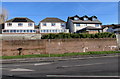
Houses above Canal Road, Cwmbach
Located between Canal Road and Tirfounder Road.
Image: © Jaggery
Taken: 9 Jan 2019
0.07 miles
5
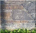
Ordnance Survey Cut Mark
This OS cut mark can be found on the wall of the chip shop, No1 Tirfounder Road. It marks a point 124.450m above mean sea level.
Image: © Adrian Dust
Taken: 26 Aug 2019
0.07 miles
6
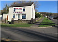
Cwmbach Chippy, Cwmbach
Fish & chips shop in Tirfounder House viewed across Tirfounder Road in January 2019.
An August 2011 Google Street View shows Rearden's fish & chips shop here.
Image: © Jaggery
Taken: 9 Jan 2019
0.08 miles
7
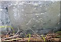
Ordnance Survey Cut Mark
This OS cut mark can be found on the wall NE side of Tirfounder Road It marks a point 120.917m above mean sea level.
Image: © Adrian Dust
Taken: 26 Aug 2019
0.09 miles
8
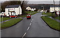
Wires over Sion Terrace, Cwmbach
Telephone wires radiate from a pole, viewed in January 2019. An August 2011 Google Street View shows that the Crown Row house behind the red car was the Crown Inn.
Image: © Jaggery
Taken: 9 Jan 2019
0.09 miles
9
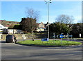
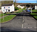
Four-lamp lamppost on a Cwmbach roundabout
On the roundabout at the Canal Road/A4059 junction.
In January 2019 an advert and direction sign for Aberdare Ford is on the roundabout.
Image: © Jaggery
Taken: 9 Jan 2019
0.09 miles
10
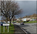
Southern boundary of Cwmbach
Viewed along Canal Road near the A4059 roundabout. Cwmbach is a village near Aberdare in the county borough of Rhondda Cynon Taf.
Image: © Jaggery
Taken: 26 Feb 2014
0.09 miles