IMAGES TAKEN NEAR TO
The Parade, FERNDALE, CF43 4SU
Introduction
This page details the photographs taken nearby to The Parade, CF43 4SU by members of the Geograph project.
The Geograph project started in 2005 with the aim of publishing, organising and preserving representative images for every square kilometre of Great Britain, Ireland and the Isle of Man.

There are currently over 7.5m images from over14,400 individuals and you can help contribute to the project by visiting https://www.geograph.org.uk
Image Map
Images are licensed for reuse under creativecommons.org/licenses/by-sa/2.0
Notes
- Clicking on the map will re-center to the selected point.
- The higher the marker number, the further away the image location is from the centre of the postcode.
Image Listing (11 Images Found)
Images are licensed for reuse under creativecommons.org/licenses/by-sa/2.0
Image
Details
Distance
1
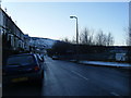
The Parade, Ferndale.
Morris Terrace on the left.
Image: © Colin Pyle
Taken: 4 Jan 2010
0.03 miles
2
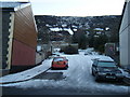
Access road where The Parade meets Ffaldau Terrace
Image: © Colin Pyle
Taken: 4 Jan 2010
0.06 miles
3
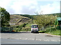
Access road to Highfield Industrial Estate, Ferndale
Viewed across The Parade, the local name for the A4233. The dark green building at the right edge of the view is Amerena House. http://www.geograph.org.uk/photo/2413651
Image: © Jaggery
Taken: 11 May 2011
0.07 miles
4
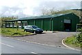
Amerena House, Ferndale
Located on the north side of The Parade (A4233), almost opposite Morris Terrace, and adjacent to the access road http://www.geograph.org.uk/photo/2413630 into Highfield Industrial Estate. The building is the premises of Sapphire Research & Electronics Ltd.
Image: © Jaggery
Taken: 11 May 2011
0.07 miles
5
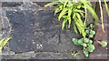
Ordnance Survey Cut Mark
This OS cut mark can be found on the wall south side of The Parade. It marks a point 274.229m above mean sea level.
Image: © Adrian Dust
Taken: 16 Jun 2017
0.10 miles
6
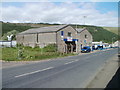
North Road Motors, Ferndale
Located on the north side of the A4233, in the west of Ferndale. Car sales & servicing, MoT test centre and filling station.
Image: © Jaggery
Taken: 11 May 2011
0.13 miles
7
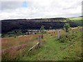
Uwchben Glynrhedynog / Above Ferndale
Llwybr ceffyl uwchben Glynrhedynog.
A bridleway above Ferndale.
Image: © Alan Richards
Taken: 1 Jul 2016
0.15 miles
8
View over the Rhondda Fach valley
Looking towards Ferndale; note the four, large concrete water tanks.
Image: © Gareth James
Taken: 4 Apr 2015
0.16 miles
9
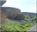
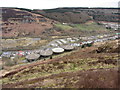
Four large concrete water tanks, Ferndale
The bowl-shaped concrete tanks are located on the south side of Ffaldau Terrace, at the northern edge of an area of moorland and quarries. There was nothing at the site to indicate their use. I am grateful to a correspondent who wrote
"These four concrete structures are water tanks. They act, or did, as a reserve water supply and now must be between 40 and 45 years old. There are one or two at the top end of the Rhondda Fawr I believe."
The top of each structure has a diameter of nearly 30 metres, giving each a circumference around the top of more than 90 metres. The tanks are in a fenced-off area. Access is from the top, hence the presence of metal ladders on the tanks, and railings around their tops.
Image: © Jaggery
Taken: 11 May 2011
0.19 miles
10
Maerdy Road Industrial Estate
Chubb Fire complex, which is located on the Eastern side of the Industrial Estate. Photograph facing North Westerly.
Image: © Kev Griffin
Taken: 16 Nov 2004
0.21 miles