IMAGES TAKEN NEAR TO
Maerdy, FERNDALE, CF43 4BN
Introduction
This page details the photographs taken nearby to CF43 4BN by members of the Geograph project.
The Geograph project started in 2005 with the aim of publishing, organising and preserving representative images for every square kilometre of Great Britain, Ireland and the Isle of Man.

There are currently over 7.5m images from over14,400 individuals and you can help contribute to the project by visiting https://www.geograph.org.uk
Image Map
Images are licensed for reuse under creativecommons.org/licenses/by-sa/2.0
Notes
- Clicking on the map will re-center to the selected point.
- The higher the marker number, the further away the image location is from the centre of the postcode.
Image Listing (42 Images Found)
Images are licensed for reuse under creativecommons.org/licenses/by-sa/2.0
Image
Details
Distance
1
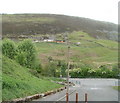
Hillside viewed from Institute Street, Maerdy
The buildings in the middle distance are part of Maerdy Farm.
Image: © Jaggery
Taken: 11 May 2011
0.07 miles
2
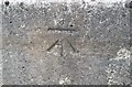
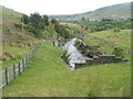
Ordnance Survey Cut Mark
This OS cut mark can be found on the bridge remains. It marks a point 273.537m above mean sea level.
Image: © Adrian Dust
Taken: 16 Jun 2017
0.10 miles
3
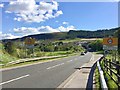
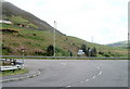
Entrance to Maerdy
A4233 from Aberdare at the entrance to Maerdy.
Image: © Alan Hughes
Taken: 4 May 2019
0.11 miles
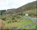
4
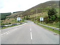
A4233 heads away from Maerdy
Heading for Aberdare, the A4233 climbs away from the NE edge of the village of Maerdy.
Image: © Jaggery
Taken: 11 May 2011
0.13 miles
5
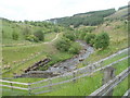
Rhondda Fach river upstream from the A4233, Maerdy
The river flows towards the conduit conveying it under the A4233. In the distance is the Avon factory. http://www.geograph.org.uk/photo/2411413
Image: © Jaggery
Taken: 11 May 2011
0.13 miles
6
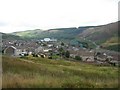
Maerdy
No longer a mining village, now reliant on modern industry - the prominent factory - or commuting. The road leads over the hill to Aberdare (the railhead and shops)
Image: © Peter Goodwin
Taken: 19 Aug 2006
0.14 miles
7
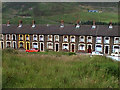
Edward Street
A typical street in a former mining community.
Image: © Russ Davies
Taken: Unknown
0.14 miles
8
A4233 junction, Maerdy
Viewed along an unnamed road http://www.geograph.org.uk/photo/2412421 from an industrial area on the north side of residential Maerdy.
The signs show left for Aberdare and Merthyr Tydfil, right for Ferndale (2 miles) and Porth (6 miles).
Image: © Jaggery
Taken: 11 May 2011
0.14 miles
9
Rhondda Fach flows away from the A4233, Maerdy
The view downstream from the edge of the A4233. Ahead, the Rhondda Fach follows a course along the NE edge of the village of Maerdy.
Image: © Jaggery
Taken: 11 May 2011
0.14 miles
10
Side view of the A4233 heading north from Maerdy
The A4233 passes through moorland at an elevation of nearly 300 metres (1000 feet) above sea level
Image: © Jaggery
Taken: 11 May 2011
0.15 miles