IMAGES TAKEN NEAR TO
Glanville Terrace, FERNDALE, CF43 4AW
Introduction
This page details the photographs taken nearby to Glanville Terrace, CF43 4AW by members of the Geograph project.
The Geograph project started in 2005 with the aim of publishing, organising and preserving representative images for every square kilometre of Great Britain, Ireland and the Isle of Man.

There are currently over 7.5m images from over14,400 individuals and you can help contribute to the project by visiting https://www.geograph.org.uk
Image Map
Images are licensed for reuse under creativecommons.org/licenses/by-sa/2.0
Notes
- Clicking on the map will re-center to the selected point.
- The higher the marker number, the further away the image location is from the centre of the postcode.
Image Listing (13 Images Found)
Images are licensed for reuse under creativecommons.org/licenses/by-sa/2.0
Image
Details
Distance
1
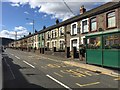
Bus stop
Bus stop at Excelsior Terrace, Maerdy.
Image: © Alan Hughes
Taken: 4 May 2019
0.01 miles
2
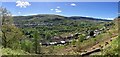
Rhondda Fach
Panoramic view of Rhondda Fach looking over Blaenllechau towards Maerdy.
Image: © Alan Hughes
Taken: 4 May 2019
0.05 miles
3
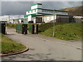
Ferndale Comprehensive School
Despite its name, the school is located in southeast Maerdy, to the north of Excelsior Terrace (A4233), though the Ferndale boundary is nearby. There are about 800 students enrolled.
Image: © Jaggery
Taken: 11 May 2011
0.13 miles
4
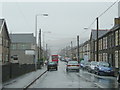
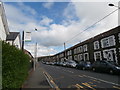
A wet afternoon in Maerdy
This is Richard Street, the main road through the town, A4233.
Looking south-east towards Ferndale.
Image: © Jonathan Billinger
Taken: 4 Oct 2008
0.13 miles
6
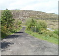
Path to the Rhondda Fach river
The path passes the eastern edge of Ferndale Comprehensive School http://www.geograph.org.uk/photo/2412937 on its way to the river.
Image: © Jaggery
Taken: 11 May 2011
0.19 miles
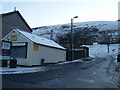
7
Maerdy Conservative Workingmen's Club
Located on Richard Street (A4233), next door to Maerdy Ex-Servicemen's Club. http://www.geograph.org.uk/photo/2412839
Image: © Jaggery
Taken: 11 May 2011
0.21 miles
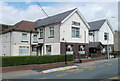
8
Heol Alfred
Takeaway at junction with Richard Street.
Image: © Colin Pyle
Taken: 4 Jan 2010
0.21 miles
9
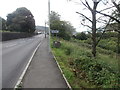
The A4233, entering Maerdy
Ferndale Comprehensive School beyond the tree.
Image: © John Lord
Taken: 11 Jul 2016
0.22 miles
10
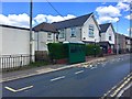
Bus stop
Bus stop outside the Maerdy Conservative Workingmen’s Club.
Image: © Alan Hughes
Taken: 4 May 2019
0.22 miles