1
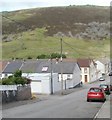
Brook Street, Maerdy
Houses on the NW side of Brook Street viewed from the Maerdy Road side. The left turn at the house with the brown door is into Oxford Street.
Image: © Jaggery
Taken: 11 May 2011
0.01 miles
2
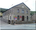
Seion Chapel, Maerdy
Image: © John Lord
Taken: 11 Jul 2016
0.04 miles
3
Football ground, Maerdy
Viewed from the edge of Blake Street. The entrance to the ground is on the far side, from Brook Street.
Image: © Jaggery
Taken: 11 May 2011
0.06 miles
4
Seion Baptist Chapel, Maerdy
Located on Maerdy Road, viewed from the corner of Brook Street. The chapel dates from 1882, as recorded in Welsh in stone on the pediment. The services were originally conducted in Welsh, but now they are in English.
Image: © Jaggery
Taken: 11 May 2011
0.07 miles
5
Telegraph Poles
Four large storage tanks in the small valley town of Maerdy - viewed through electricity supply poles above Blaenllechau.
Image: © Alan Hughes
Taken: 4 May 2019
0.07 miles
6
Ordnance Survey Cut Mark
This OS cut mark can be found on the wall SW side of Maerdy Road. It marks a point 296.253m above mean sea level.
Image: © Adrian Dust
Taken: 16 Jun 2017
0.07 miles
7
Blake Street, Maerdy
Blake Street follows an inverted-L course on the north side of Maerdy Road (A4233). This view is from the angle of the L, look along houses furthest away from Maerdy Road.
Image: © Jaggery
Taken: 11 May 2011
0.09 miles
8
Ty's fish and chip shop, Maerdy
Located at 50 Richard Street (A4233) and Heol Alfred.
Image: © Jaggery
Taken: 11 May 2011
0.14 miles
9
Maerdy Ex-Servicemen's Club
Located on Richard St (A4233), next door to the Conservative club, http://www.geograph.org.uk/photo/2412846 and facing Ty's fish and chip shop. http://www.geograph.org.uk/photo/2412736
Image: © Jaggery
Taken: 11 May 2011
0.14 miles
10
Entrance to Maerdy Junior School
The entrance is at the SE side of the school. Vehicles reach the school from the A4233 along a looping road, Heol Alfred, which bends through 270 degrees. Pedestrians have the alternative of a shorter, steeper route up steps http://www.geograph.org.uk/photo/2412877
Image: © Jaggery
Taken: 11 May 2011
0.14 miles


