IMAGES TAKEN NEAR TO
Heol Teifionydd, FERNDALE, CF43 3RW
Introduction
This page details the photographs taken nearby to Heol Teifionydd, CF43 3RW by members of the Geograph project.
The Geograph project started in 2005 with the aim of publishing, organising and preserving representative images for every square kilometre of Great Britain, Ireland and the Isle of Man.

There are currently over 7.5m images from over14,400 individuals and you can help contribute to the project by visiting https://www.geograph.org.uk
Image Map (Loading...)


Getting Data...Please wait
Leaflet Map data © OpenStreetMap
Images are licensed for reuse under creativecommons.org/licenses/by-sa/2.0
Notes
- Clicking on the map will re-center to the selected point.
- The higher the marker number, the further away the image location is from the centre of the postcode.
Image Listing (69 Images Found)
Images are licensed for reuse under creativecommons.org/licenses/by-sa/2.0
Image
Details
Distance
1
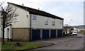
Heol Teifionydd lockup garages, Penhrys
Near the Heol Pendyrus junction.
Image: © Jaggery
Taken: 30 Mar 2015
0.01 miles
2
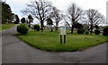
Penrhys Cemetery path fork
Near the cemetery entrance. http://www.geograph.org.uk/photo/4424154
Image: © Jaggery
Taken: 30 Mar 2015
0.04 miles
3
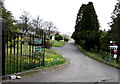
Entrance to Penrhys Cemetery
From Heol Pendyrus in the south of the village.
Image: © Jaggery
Taken: 30 Mar 2015
0.05 miles
4
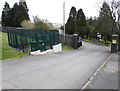
Gas installation near the entrance to Penrhys Cemetery
The Wales & West Utilities installation is inside a locked metal compound.
Image: © Jaggery
Taken: 30 Mar 2015
0.05 miles
5
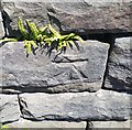
Ordnance Survey Cut Mark
This OS cut mark can be found on the wall of the cemetery on Penrhys Road. It marks a point 282.666m above mean sea level.
Image: © Adrian Dust
Taken: 18 Jun 2017
0.06 miles
6
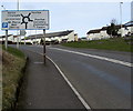
Destinations sign on the approach to a roundabout, Penrhys
Alongside the B4512 Penrhys Road from Tylorstown.
Image: © Jaggery
Taken: 30 Mar 2015
0.07 miles
7
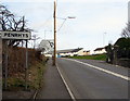
SE boundary of Penrhys
The sign is alongside the B4512 Penrhys Road from Tylorstown.
Both locations are in the county borough of Rhondda Cynon Taf.
Image: © Jaggery
Taken: 30 Mar 2015
0.07 miles
8
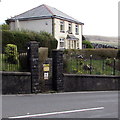
Penrhys Cemetery lodge
The lodge is at the southern edge of the cemetery, viewed across the B4512 Penrhys Road.
Image: © Jaggery
Taken: 30 Mar 2015
0.07 miles
9
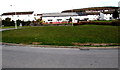
Large grassy roundabout in Penrhys
At the junction of Penrhys Road and Heol Pendyrus, the roundabout is about 50 metres by 35 metres.
Image: © Jaggery
Taken: 30 Mar 2015
0.07 miles
10
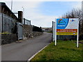
Vehicles entrance to Penrhys Primary School
From Heol Ioan. Maximum speed 5 mph. No pedestrian access.
Image: © Jaggery
Taken: 30 Mar 2015
0.07 miles