IMAGES TAKEN NEAR TO
Heol Mair, FERNDALE, CF43 3PY
Introduction
This page details the photographs taken nearby to Heol Mair, CF43 3PY by members of the Geograph project.
The Geograph project started in 2005 with the aim of publishing, organising and preserving representative images for every square kilometre of Great Britain, Ireland and the Isle of Man.

There are currently over 7.5m images from over14,400 individuals and you can help contribute to the project by visiting https://www.geograph.org.uk
Image Map
Images are licensed for reuse under creativecommons.org/licenses/by-sa/2.0
Notes
- Clicking on the map will re-center to the selected point.
- The higher the marker number, the further away the image location is from the centre of the postcode.
Image Listing (61 Images Found)
Images are licensed for reuse under creativecommons.org/licenses/by-sa/2.0
Image
Details
Distance
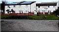
1
Penrhys houses
Viewed from Heol Pendyrus looking across Heol Dyfed towards Heol Mair.
Image: © Jaggery
Taken: 30 Mar 2015
0.05 miles
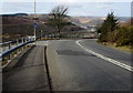
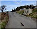
2
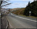
Steep descent from Penrhys towards Ystrad
The B4512 Penrhys Road descends past the back of the Penrhys boundary sign on the right. http://www.geograph.org.uk/photo/4409579
A nearby sign shows a 12% gradient http://www.geograph.org.uk/photo/4409487 (between 1 in 8 and 1 in 9).
Image: © Jaggery
Taken: 30 Mar 2015
0.09 miles
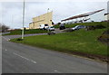
3
Rooftop solar panels, Heol Pendyrus, Penrhys
On the NW side of this large grassy roundabout. http://www.geograph.org.uk/photo/4419219
Image: © Jaggery
Taken: 30 Mar 2015
0.10 miles
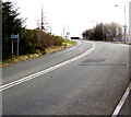
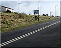
4
12% descent towards Ystrad from Penrhys
The sign is alongside the B4512 Penrhys Road. A 12% gradient is between 1 in 8 and 1 in 9.
Image: © Jaggery
Taken: 30 Mar 2015
0.10 miles
5
Left turn for Rhondda Golf Club, Penrhys
The left turn from the B4512 Penrhys Road leads to this http://www.geograph.org.uk/photo/4409725 road.
Image: © Jaggery
Taken: 30 Mar 2015
0.11 miles
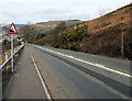
6
Western boundary of Penrhys
The boundary sign is alongside the B4512 Penrhys Road near the top of a long steep climb from Ystrad.
Below the boundary sign, a brown sign points right towards Rhondda Golf Club.
Image: © Jaggery
Taken: 30 Mar 2015
0.11 miles
7
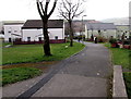
Penrhys footpath
Between houses in Heol Mair and Heol Ioan.
Image: © Jaggery
Taken: 30 Mar 2015
0.11 miles
8
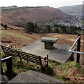
Penrhys bench with a view towards Llwynypia
At a height of 275 metres (900 ft) above sea level, the bench at the edge of the B4512
Penrhys Road commands views http://www.geograph.org.uk/photo/4419137 towards Llwynypia in the valley of the Rhondda Fawr river.
The directions and locations information on the tablet in front of the bench have faded to illegibility.
Image: © Jaggery
Taken: 30 Mar 2015
0.12 miles
9
Golf course road approaches Penrhys Road, Penrhys
The road from Rhondda Golf Club passes a Western Power Distribution electricity substation. http://www.geograph.org.uk/photo/4409739
Image: © Jaggery
Taken: 30 Mar 2015
0.12 miles
10
Nearly at the top of the climb up the B4512, Penrhys
The long steep ascent from Ystrad ends a few tens of metres beyond the directions sign.
Image: © Jaggery
Taken: 30 Mar 2015
0.12 miles