IMAGES TAKEN NEAR TO
Heol Dyfed, FERNDALE, CF43 3PT
Introduction
This page details the photographs taken nearby to Heol Dyfed, CF43 3PT by members of the Geograph project.
The Geograph project started in 2005 with the aim of publishing, organising and preserving representative images for every square kilometre of Great Britain, Ireland and the Isle of Man.

There are currently over 7.5m images from over14,400 individuals and you can help contribute to the project by visiting https://www.geograph.org.uk
Image Map
Images are licensed for reuse under creativecommons.org/licenses/by-sa/2.0
Notes
- Clicking on the map will re-center to the selected point.
- The higher the marker number, the further away the image location is from the centre of the postcode.
Image Listing (63 Images Found)
Images are licensed for reuse under creativecommons.org/licenses/by-sa/2.0
Image
Details
Distance
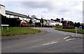
1
Rooftop solar panels, Heol Pendyrus, Penrhys
On the NW side of this large grassy roundabout. http://www.geograph.org.uk/photo/4419219
Image: © Jaggery
Taken: 30 Mar 2015
0.01 miles
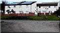
2
Large grassy roundabout in Penrhys
At the junction of Penrhys Road and Heol Pendyrus, the roundabout is about 50 metres by 35 metres.
Image: © Jaggery
Taken: 30 Mar 2015
0.04 miles
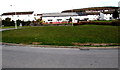
3
Heol Pendyrus, Penrhys
Heol Pendyrus is the outer circular road around residential Penrhys.
Here, Heol Pendyrus approaches the roundabout at the B4512 Penrhys Road junction.
The black arrow on a sign points left towards the Arts Centre.
Image: © Jaggery
Taken: 30 Mar 2015
0.04 miles
4
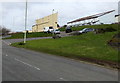
Penrhys houses
Viewed from Heol Pendyrus looking across Heol Dyfed towards Heol Mair.
Image: © Jaggery
Taken: 30 Mar 2015
0.05 miles
5
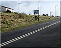
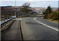
Low gear for 1 mile on the descent from Penrhys to Ystrad
The sign is alongside the B4512 Penrhys Road. Ahead, a sign shows a 12% gradient. http://www.geograph.org.uk/photo/4409487
Image: © Jaggery
Taken: 30 Mar 2015
0.05 miles
6
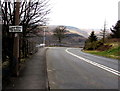
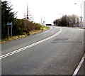
Nearly at the top of the climb up the B4512, Penrhys
The long steep ascent from Ystrad ends a few tens of metres beyond the directions sign.
Image: © Jaggery
Taken: 30 Mar 2015
0.06 miles
7
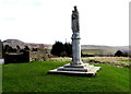
Our Lady and Jesus statue, Penrhys
Located at the southern edge of the village, at about 285 metres (c935 ft) above sea level. A nearby information board records that the area where Penrhys is now has a long and rich history. As a religious site dedicated to Our Lady Mary it was one of the most famous medieval pilgrimage sites. The shrine was used as a healing spring and was reputed to cure rheumatism and eye disorders. A statue of Mary nursing the infant Jesus marked the shrine site for many centuries, until the 1530s, the decade of the Dissolution of the Monasteries during the reign of King Henry VIII. On the orders of Thomas Cromwell, the King's chancellor, it was taken down to be publicly destroyed in London.
The statue seen here was carved from Portland Stone in the early 1950s using a design based on descriptions of the original recorded in medieval Welsh poetry. The Archbsishop of Cardiff blessed the statue on July 2nd 1953.
Image: © Jaggery
Taken: 30 Mar 2015
0.07 miles
8
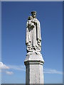
Statue, Our Lady of Penrhys
Erected in 1953 and carved from Portland stone, the modern statue of Our Lady of Penrhys looks out across the valley. For centuries Penrhys has attracted pilgrims; in mediaeval times a monastery and a holy well with a 'wonder-working' statue were situated nearby. At the dissolution of the monasteries the original statue was burned down.
Image: © Fiona Andrew
Taken: 26 Jul 2008
0.07 miles
9
Left turn for Rhondda Golf Club, Penrhys
The left turn from the B4512 Penrhys Road leads to this http://www.geograph.org.uk/photo/4409725 road.
Image: © Jaggery
Taken: 30 Mar 2015
0.07 miles
10
Western boundary of Penrhys
The boundary sign is alongside the B4512 Penrhys Road near the top of a long steep climb from Ystrad.
Below the boundary sign, a brown sign points right towards Rhondda Golf Club.
Image: © Jaggery
Taken: 30 Mar 2015
0.07 miles